Difference between revisions of "2014-02-02 34 -118"
From Geohashing
imported>Bravissimo594 m ([live picture] No friends to play with. :-( [http://www.openstreetmap.org/?lat=34.77670000&lon=-118.04800000&zoom=16&layers=B000FTF @34.7767,-118.0480]) |
imported>Bravissimo594 m ([live picture] Hash point is 100 meters on the "good side" of this barbed wire fence belonging, I believe, to Edwards Air Force Base. [http://www.openstreetmap.org/?lat=34.77770000&lon=-118.04800000&zoom=16&layers=B000FTF @34.7777,-118.0480]) |
||
| Line 49: | Line 49: | ||
Image:2014-02-02_34_-118_10-40-59-178.jpg | No friends to play with. :-( [http://www.openstreetmap.org/?lat=34.77670000&lon=-118.04800000&zoom=16&layers=B000FTF @34.7767,-118.0480] | Image:2014-02-02_34_-118_10-40-59-178.jpg | No friends to play with. :-( [http://www.openstreetmap.org/?lat=34.77670000&lon=-118.04800000&zoom=16&layers=B000FTF @34.7767,-118.0480] | ||
| + | |||
| + | Image:2014-02-02_34_-118_10-43-55-556.jpg | Hash point is 100 meters on the "good side" of this barbed wire fence belonging, I believe, to Edwards Air Force Base. [http://www.openstreetmap.org/?lat=34.77770000&lon=-118.04800000&zoom=16&layers=B000FTF @34.7777,-118.0480] | ||
</gallery> | </gallery> | ||
Revision as of 18:44, 2 February 2014
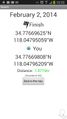
| Sun 2 Feb 2014 in 34,-118: 34.7766962, -118.0479506 geohashing.info google osm bing/os kml crox |
Location
In the Mojave Desert, northeast of Lancaster.
Participants
Plans
I will drive by and let a couple of puppies stretch their legs out on the way to visit a friend in Tehachapi. Maybe there will be fauna to play with. I currently plan to be at the hashpoint at 10:00am on Sunday. Bravissimo594 (talk) 18:41, 1 February 2014 (EST)
Expedition
- Made it to Palmdale. Probably 20 minutes away. -- Bravissimo594 (talk) @34.6542,-118.1475 13:00, 2 February 2014 (EST)
Tracklog
Photos
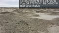
The spot ... just like all the others around here. @34.7767,-118.0480
Success!
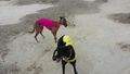
No friends to play with. :-( @34.7767,-118.0480
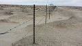
Hash point is 100 meters on the "good side" of this barbed wire fence belonging, I believe, to Edwards Air Force Base. @34.7777,-118.0480


Achievements