Difference between revisions of "2014-02-06 54 -2"
From Geohashing
imported>Angel m (→Achievements: fixing categories) |
m |
||
| (2 intermediate revisions by 2 users not shown) | |||
| Line 15: | Line 15: | ||
}} | }} | ||
| − | + | ||
__NOTOC__ | __NOTOC__ | ||
== Location == | == Location == | ||
| − | + | ||
In a field somewhere off a road past Halton. | In a field somewhere off a road past Halton. | ||
== Participants == | == Participants == | ||
| − | + | ||
| − | + | * [[User:Angel|Angel]] | |
| − | [[User:Angel|Angel]] | ||
== Plans == | == Plans == | ||
| − | + | ||
Walk up the cyclepath, see if I can get there, return to Lancaster via Quernmore. | Walk up the cyclepath, see if I can get there, return to Lancaster via Quernmore. | ||
== Expedition == | == Expedition == | ||
| − | + | ||
Went part way; blood sugar went low; panicked and aborted with 4.5 miles to go. | Went part way; blood sugar went low; panicked and aborted with 4.5 miles to go. | ||
| − | == | + | == Photos == |
| − | |||
| − | |||
| − | |||
| − | |||
| − | |||
<gallery perrow="5"> | <gallery perrow="5"> | ||
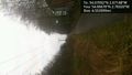
Image:2014-02-06_54_-2_09-46-56-671.jpg | Pretty sure this'll end up 'private property', but must be worth a try [http://www.openstreetmap.org/?lat=54.05378129&lon=-2.79098544&zoom=16&layers=B000FTF @54.0538,-2.7910] | Image:2014-02-06_54_-2_09-46-56-671.jpg | Pretty sure this'll end up 'private property', but must be worth a try [http://www.openstreetmap.org/?lat=54.05378129&lon=-2.79098544&zoom=16&layers=B000FTF @54.0538,-2.7910] | ||
| − | |||
Image:2014-02-06_54_-2_10-25-14-435.jpg | Aborted due to low blood sugar :( [http://www.openstreetmap.org/?lat=54.06670000&lon=-2.78320000&zoom=16&layers=B000FTF @54.0667,-2.7832] | Image:2014-02-06_54_-2_10-25-14-435.jpg | Aborted due to low blood sugar :( [http://www.openstreetmap.org/?lat=54.06670000&lon=-2.78320000&zoom=16&layers=B000FTF @54.0667,-2.7832] | ||
</gallery> | </gallery> | ||
| Line 53: | Line 46: | ||
| − | |||
| − | |||
| − | |||
| − | |||
| − | |||
| − | |||
| − | |||
| − | |||
[[Category:Expeditions]] | [[Category:Expeditions]] | ||
[[Category:Expeditions with photos]] | [[Category:Expeditions with photos]] | ||
[[Category:Coordinates not reached]] | [[Category:Coordinates not reached]] | ||
| + | [[Category:Not reached - Injury]] | ||
| + | {{location|GB|ENG|LAN}} | ||
Latest revision as of 18:12, 28 March 2022
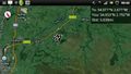
| Thu 6 Feb 2014 in 54,-2: 54.0709214, -2.6714825 geohashing.info google osm bing/os kml crox |
Location
In a field somewhere off a road past Halton.
Participants
Plans
Walk up the cyclepath, see if I can get there, return to Lancaster via Quernmore.
Expedition
Went part way; blood sugar went low; panicked and aborted with 4.5 miles to go.
Photos
Pretty sure this'll end up 'private property', but must be worth a try @54.0538,-2.7910
Aborted due to low blood sugar :( @54.0667,-2.7832

