Difference between revisions of "2014-02-11 34 -118"
From Geohashing
imported>Bravissimo594 m ([live picture] The spot is on the dirt area behind this marker I left nearby. [http://www.openstreetmap.org/?lat=34.16220000&lon=-118.13100000&zoom=16&layers=B000FTF @34.1622,-118.1310]) |
imported>Bravissimo594 m ([live picture] Grinning on a sunny February day. [http://www.openstreetmap.org/?lat=34.16220000&lon=-118.13100000&zoom=16&layers=B000FTF @34.1622,-118.1310]) |
||
| Line 49: | Line 49: | ||
Image:2014-02-11_34_-118_13-19-47-424.jpg | The spot is on the dirt area behind this marker I left nearby. [http://www.openstreetmap.org/?lat=34.16220000&lon=-118.13100000&zoom=16&layers=B000FTF @34.1622,-118.1310] | Image:2014-02-11_34_-118_13-19-47-424.jpg | The spot is on the dirt area behind this marker I left nearby. [http://www.openstreetmap.org/?lat=34.16220000&lon=-118.13100000&zoom=16&layers=B000FTF @34.1622,-118.1310] | ||
| + | |||
| + | Image:2014-02-11_34_-118_13-20-38-057.jpg | Grinning on a sunny February day. [http://www.openstreetmap.org/?lat=34.16220000&lon=-118.13100000&zoom=16&layers=B000FTF @34.1622,-118.1310] | ||
</gallery> | </gallery> | ||
Revision as of 21:20, 11 February 2014

| Tue 11 Feb 2014 in 34,-118: 34.1621573, -118.1312442 geohashing.info google osm bing/os kml crox |
Location
A residential driveway in Pasadena. Los Angeles graticule.
Participants
Plans
- I plan to stop by the hash point either at about 1:30pm or closer to 4:30pm and will update this section as plans become more clear. Bravissimo594 (talk) 13:06, 11 February 2014 (EST)
- I now believe I will stop by the point at about 1:15pm. Bravissimo594 (talk) 15:48, 11 February 2014 (EST)
Poster
Expedition
Tracklog
Photos

Geohash Droid details. Success! @34.1622,-118.1310
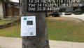
The spot is on the dirt area behind this marker I left nearby. @34.1622,-118.1310
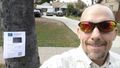
Grinning on a sunny February day. @34.1622,-118.1310


Achievements