Difference between revisions of "2014-03-11 20 -103"
From Geohashing
imported>Elwicho (Created page with "{{subst:Expedition |lat = 20 |lon = 103 |date = 2014-03-11 |image =File:Wich2014-03-11 17.41.27.png }}") |
m |
||
| (6 intermediate revisions by 3 users not shown) | |||
| Line 2: | Line 2: | ||
<!-- If you did not specify these parameters in the template, please substitute appropriate values for IMAGE, LAT, LON, and DATE (YYYY-MM-DD format) | <!-- If you did not specify these parameters in the template, please substitute appropriate values for IMAGE, LAT, LON, and DATE (YYYY-MM-DD format) | ||
| − | [[ | + | [[File:2014-03-11 18.00.09.jpg|thumb|left]] |
Remove this section if you don't want an image at the top (left) of your report. You should remove the "Image:" or "File:" | Remove this section if you don't want an image at the top (left) of your report. You should remove the "Image:" or "File:" | ||
| Line 11: | Line 11: | ||
{{meetup graticule | {{meetup graticule | ||
| lat=20 | | lat=20 | ||
| − | | lon=103 | + | | lon=-103 |
| date=2014-03-11 | | date=2014-03-11 | ||
}} | }} | ||
| Line 19: | Line 19: | ||
== Location == | == Location == | ||
<!-- where you've surveyed the hash to be --> | <!-- where you've surveyed the hash to be --> | ||
| + | umm guadalajara mexico. | ||
== Participants == | == Participants == | ||
<!-- who attended: If you link to your wiki user name in this section, your expedition will be picked up by the various statistics generated for geohashing. You may use three tildes ~ as a shortcut to automatically insert the user signature of the account you are editing with. | <!-- who attended: If you link to your wiki user name in this section, your expedition will be picked up by the various statistics generated for geohashing. You may use three tildes ~ as a shortcut to automatically insert the user signature of the account you are editing with. | ||
--> | --> | ||
| − | + | [[User:Elwicho|Elwicho]] ([[User talk:Elwicho|talk]]) | |
== Plans == | == Plans == | ||
<!-- what were the original plans --> | <!-- what were the original plans --> | ||
| + | i was not planning on going but had the app and used it often, i was the first time it was more or less close by | ||
== Expedition == | == Expedition == | ||
| − | <!-- how it all turned out. your narrative goes here. --> | + | <!-- how it all turned out. your narrative goes here. --> |
| + | well it was a quick drive but it ended quite abruptly due to a failure in diplomacy eg:old lady thought i was a narco or something. | ||
| + | so i got only to about 10 m of the site :/ | ||
== Tracklog == | == Tracklog == | ||
| Line 38: | Line 42: | ||
--> | --> | ||
<gallery perrow="5"> | <gallery perrow="5"> | ||
| + | File:Wich2014-03-11_17.41.27.png | oh my there is one i can reach! | ||
| + | File:2014-03-11 18.00.09.jpg | passing the most emblematic thing on guadalajara | ||
| + | File:2014-03-11 18.21.15.png | yey got there! | ||
| + | File:2014-03-11 18.21.29.jpg | critical diplomacy failure | ||
</gallery> | </gallery> | ||
| Line 43: | Line 51: | ||
{{#vardefine:ribbonwidth|800px}} | {{#vardefine:ribbonwidth|800px}} | ||
<!-- Add any achievement ribbons you earned below, or remove this section --> | <!-- Add any achievement ribbons you earned below, or remove this section --> | ||
| + | {{No trespassing | ||
| + | | latitude = 20 | ||
| + | | longitude = -103 | ||
| + | | date = 2014-03-11 | ||
| + | | name = luis | ||
| + | | distance = 15m | ||
| − | + | }} | |
| − | |||
| − | |||
| − | |||
| − | |||
| − | |||
| − | |||
| − | |||
| − | |||
| − | |||
| − | |||
[[Category:Expeditions]] | [[Category:Expeditions]] | ||
| − | |||
[[Category:Expeditions with photos]] | [[Category:Expeditions with photos]] | ||
| − | |||
| − | |||
| − | |||
| − | |||
| − | |||
| − | |||
| − | |||
| − | |||
| − | |||
[[Category:Coordinates not reached]] | [[Category:Coordinates not reached]] | ||
| − | |||
| − | |||
| − | |||
| − | |||
| − | |||
[[Category:Not reached - No public access]] | [[Category:Not reached - No public access]] | ||
| − | + | {{location|MX|JAL}} | |
| − | |||
| − | |||
| − | |||
| − | |||
| − | |||
| − | |||
| − | |||
Latest revision as of 14:00, 22 September 2021
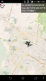
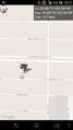
| Tue 11 Mar 2014 in 20,-103: 20.6868412, -103.3840468 geohashing.info google osm bing/os kml crox |
Location
umm guadalajara mexico.
Participants
Plans
i was not planning on going but had the app and used it often, i was the first time it was more or less close by
Expedition
well it was a quick drive but it ended quite abruptly due to a failure in diplomacy eg:old lady thought i was a narco or something.
so i got only to about 10 m of the site :/
Tracklog
Photos
oh my there is one i can reach!
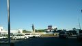
passing the most emblematic thing on guadalajara
yey got there!

critical diplomacy failure


Achievements
luis earned the No trespassing consolation prize
|