Difference between revisions of "2014-03-22 34 -120"
From Geohashing
imported>S0meb0dy ([live picture] Down Highway 135 [http://www.openstreetmap.org/?lat=34.74401281&lon=-120.27717746&zoom=16&layers=B000FTF @34.7440,-120.2772]) |
imported>S0meb0dy ([live picture] Posted message for future visitors. [http://www.openstreetmap.org/?lat=34.74393617&lon=-120.27709211&zoom=16&layers=B000FTF @34.7439,-120.2771]) |
||
| Line 44: | Line 44: | ||
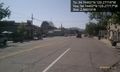
Image:2014-03-22_34_-120_15-26-33-268.jpg | Down Highway 135 [http://www.openstreetmap.org/?lat=34.74401281&lon=-120.27717746&zoom=16&layers=B000FTF @34.7440,-120.2772] | Image:2014-03-22_34_-120_15-26-33-268.jpg | Down Highway 135 [http://www.openstreetmap.org/?lat=34.74401281&lon=-120.27717746&zoom=16&layers=B000FTF @34.7440,-120.2772] | ||
| + | |||
| + | Image:2014-03-22_34_-120_15-35-42-657.jpg | Posted message for future visitors. [http://www.openstreetmap.org/?lat=34.74393617&lon=-120.27709211&zoom=16&layers=B000FTF @34.7439,-120.2771] | ||
</gallery> | </gallery> | ||
Revision as of 22:35, 22 March 2014
| Sat 22 Mar 2014 in 34,-120: 34.7440204, -120.2771792 geohashing.info google osm bing/os kml crox |
Location
Participants
Plans
Expedition
- Success! -- S0meb0dy (talk) @34.7440,-120.2772 15:23, 22 March 2014 (PDT)
Tracklog
Photos
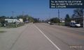
Up Highway 135 @34.7440,-120.2772
Down Highway 135 @34.7440,-120.2772
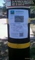
Posted message for future visitors. @34.7439,-120.2771


Achievements