Difference between revisions of "2014-04-16 49 8"
From Geohashing
imported>DODO (→Expedition) |
|||
| (7 intermediate revisions by 2 users not shown) | |||
| Line 17: | Line 17: | ||
<!-- edit as necessary --> | <!-- edit as necessary --> | ||
__NOTOC__ | __NOTOC__ | ||
| + | |||
| + | [[2014-04-12_48_8|previous]] [[2014-04-18 49 8|next]] | ||
| + | |||
== Location == | == Location == | ||
<!-- where you've surveyed the hash to be --> | <!-- where you've surveyed the hash to be --> | ||
| Line 32: | Line 35: | ||
== Expedition == | == Expedition == | ||
<!-- how it all turned out. your narrative goes here. --> | <!-- how it all turned out. your narrative goes here. --> | ||
| − | I tried to get there on my way to work, but 190 m before I reached the hash, there was an -open- rolling gate and a no trespassing sign. As there was no one to ask for permission, I decided not to go on and turned around. Some photos will follow this evening. | + | I tried to get there on my way to work, but 190 m before I reached the hash, there was an -open- rolling gate and a no trespassing sign. As there was no one to ask for permission, I decided not to go on and turned around. I couldn't come nearer to the hashpoint on my way around the gated area either. Some photos will follow this evening. |
== Tracklog == | == Tracklog == | ||
<!-- if your GPS device keeps a log, you may post a link here --> | <!-- if your GPS device keeps a log, you may post a link here --> | ||
| + | [[http://www.gpsies.com/map.do?fileId=hxfvvljdpnyzigfm 7KM of bullriding]] | ||
== Photos == | == Photos == | ||
| Line 42: | Line 46: | ||
--> | --> | ||
<gallery perrow="5"> | <gallery perrow="5"> | ||
| + | Image:2014-04-16_49_8-1.jpg | No trespassing, no photo | ||
| + | Image:2014-04-16_49_8-2.jpg | Unhappy geohasher ;-) | ||
| + | Image:2014-04-16_49_8-3.jpg | View from the gate back to Speyer | ||
</gallery> | </gallery> | ||
| Line 47: | Line 54: | ||
{{#vardefine:ribbonwidth|800px}} | {{#vardefine:ribbonwidth|800px}} | ||
<!-- Add any achievement ribbons you earned below, or remove this section --> | <!-- Add any achievement ribbons you earned below, or remove this section --> | ||
| + | {{No trespassing | ||
| + | | latitude = 49 | ||
| + | | longitude = 8 | ||
| + | | date = 2014-04-16 | ||
| + | | name = DODO | ||
| + | | distance = 190m | ||
| − | + | }} | |
| − | |||
| − | |||
| − | |||
| − | |||
| − | |||
| − | |||
| − | |||
| − | |||
| − | |||
[[Category:Expeditions]] | [[Category:Expeditions]] | ||
| − | |||
| − | |||
| − | |||
| − | |||
| − | |||
| − | |||
| − | |||
| − | |||
| − | |||
| − | |||
| − | |||
[[Category:Coordinates not reached]] | [[Category:Coordinates not reached]] | ||
| − | |||
| − | |||
| − | |||
| − | |||
| − | |||
[[Category:Not reached - No public access]] | [[Category:Not reached - No public access]] | ||
| − | + | {{location|DE|RP|SP}} | |
| − | |||
| − | |||
| − | |||
| − | |||
| − | |||
| − | |||
| − | |||
Latest revision as of 11:22, 26 April 2020
| Wed 16 Apr 2014 in 49,8: 49.2914580, 8.4657704 geohashing.info google osm bing/os kml crox |
Location
In the industrial area in the south of Speyer.
Participants
Plans
Only 6 KM from home and a 6 KM detour (both ways) on my way to work. Probably on private property but nevertheless to close not to try. First attempt before 8 tomorrow morning. In the unlikely case that someone wants to accompany me, I could come back on my way home around 5 pm.
Expedition
I tried to get there on my way to work, but 190 m before I reached the hash, there was an -open- rolling gate and a no trespassing sign. As there was no one to ask for permission, I decided not to go on and turned around. I couldn't come nearer to the hashpoint on my way around the gated area either. Some photos will follow this evening.
Tracklog
Photos
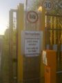
No trespassing, no photo
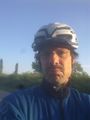
Unhappy geohasher ;-)
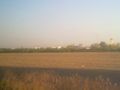
View from the gate back to Speyer


Achievements
DODO earned the No trespassing consolation prize
|