Difference between revisions of "2014-04-30 49 8"
imported>DODO (→Expedition) |
|||
| (4 intermediate revisions by 2 users not shown) | |||
| Line 17: | Line 17: | ||
<!-- edit as necessary --> | <!-- edit as necessary --> | ||
__NOTOC__ | __NOTOC__ | ||
| + | [[2014-04-23_49_8|previous]] [[2014-05-02 49 8|next]] | ||
| + | |||
== Location == | == Location == | ||
<!-- where you've surveyed the hash to be --> | <!-- where you've surveyed the hash to be --> | ||
| Line 32: | Line 34: | ||
== Expedition == | == Expedition == | ||
<!-- how it all turned out. your narrative goes here. --> | <!-- how it all turned out. your narrative goes here. --> | ||
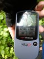
| − | The way near the hash was uneventful. The hash lies in a little forest, that is frequently visited by dog owners, I must have met at least 20 of them in ten minutes.Near (50 m) the hash I parked my bull on a small path but in the direction of the hash was a wooden fence, that fences some dense copse. I walked around the fence, what brings me even closer to the hash, down to 25 m. Not close enough :-( | + | The way near the hash was uneventful. The hash lies in a little forest, that is frequently visited by dog owners, I must have met at least 20 of them in ten minutes. Near (50 m) the hash I parked my bull on a small path but in the direction of the hash was a wooden fence, that fences some dense copse. I walked around the fence, what brings me even closer to the hash, down to 25 m. Not close enough :-( |
== Tracklog == | == Tracklog == | ||
<!-- if your GPS device keeps a log, you may post a link here --> | <!-- if your GPS device keeps a log, you may post a link here --> | ||
| + | [http://www.gpsies.com/map.do?fileId=bychnhbssaifpyzs bull: 33 KM] | ||
== Photos == | == Photos == | ||
<!-- Insert pictures between the gallery tags using the following format: | <!-- Insert pictures between the gallery tags using the following format: | ||
| − | Image: | + | Image:2014-04-30_49_8-1.jpg | Witty Comment |
--> | --> | ||
| − | <gallery perrow=" | + | <gallery perrow="6"> |
| + | Image:2014-04-30_49_8-1.jpg |Bull-parking (and a bit of my finger) | ||
| + | Image:2014-04-30_49_8-2.jpg | The fence from the one side | ||
| + | Image:2014-04-30_49_8-3.jpg | The fence from the other side | ||
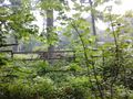
| + | Image:2014-04-30_49_8-4.jpg | As close as I could get | ||
| + | Image:2014-04-30_49_8-5.jpg | That's how it lookes behind the fence. Not very inviting either. | ||
| + | Image:2014-04-30_49_8-6.jpg | The ferry once again, this time in the opposite direction | ||
</gallery> | </gallery> | ||
| Line 47: | Line 56: | ||
{{#vardefine:ribbonwidth|800px}} | {{#vardefine:ribbonwidth|800px}} | ||
<!-- Add any achievement ribbons you earned below, or remove this section --> | <!-- Add any achievement ribbons you earned below, or remove this section --> | ||
| + | {{No trespassing | ||
| + | | latitude = 49 | ||
| + | | longitude = 8 | ||
| + | | date = 2014-04-30 | ||
| + | | name = DODO | ||
| + | | distance = 25m | ||
| − | + | }} | |
| − | |||
| − | |||
| − | |||
| − | |||
| − | |||
| − | |||
| − | |||
| − | |||
| − | |||
[[Category:Expeditions]] | [[Category:Expeditions]] | ||
| − | |||
| − | |||
| − | |||
| − | |||
| − | |||
| − | |||
| − | |||
| − | |||
| − | |||
| − | |||
| − | |||
[[Category:Coordinates not reached]] | [[Category:Coordinates not reached]] | ||
| − | |||
| − | |||
| − | |||
| − | |||
| − | |||
[[Category:Not reached - No public access]] | [[Category:Not reached - No public access]] | ||
| − | + | {{location|DE|RP|RP}} | |
| − | |||
| − | |||
| − | |||
| − | |||
| − | |||
| − | |||
| − | |||
Latest revision as of 11:17, 29 April 2020
| Wed 30 Apr 2014 in 49,8: 49.4201760, 8.3690883 geohashing.info google osm bing/os kml crox |
Location
In a forest near Limburgerhof
Participants
Plans
To pass by on my way to work this morning. I try to arrive before 9 am.
Expedition
The way near the hash was uneventful. The hash lies in a little forest, that is frequently visited by dog owners, I must have met at least 20 of them in ten minutes. Near (50 m) the hash I parked my bull on a small path but in the direction of the hash was a wooden fence, that fences some dense copse. I walked around the fence, what brings me even closer to the hash, down to 25 m. Not close enough :-(
Tracklog
Photos
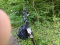
Bull-parking (and a bit of my finger)
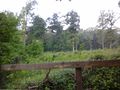
The fence from the one side
The fence from the other side
As close as I could get
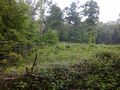
That's how it lookes behind the fence. Not very inviting either.
The ferry once again, this time in the opposite direction


Achievements
DODO earned the No trespassing consolation prize
|