Difference between revisions of "2014-05-01 51 11"
imported>TFTD (Plans added.) |
imported>TFTD (Content) |
||
| Line 2: | Line 2: | ||
<!-- If you did not specify these parameters in the template, please substitute appropriate values for IMAGE, LAT, LON, and DATE (YYYY-MM-DD format) | <!-- If you did not specify these parameters in the template, please substitute appropriate values for IMAGE, LAT, LON, and DATE (YYYY-MM-DD format) | ||
| − | [[Image:{{{ | + | [[Image:{{{2014-05-01 51-11 005.jpg|IMAGE}}}|thumb|left]] |
Remove this section if you don't want an image at the top (left) of your report. You should remove the "Image:" or "File:" | Remove this section if you don't want an image at the top (left) of your report. You should remove the "Image:" or "File:" | ||
| Line 30: | Line 30: | ||
== Expedition == | == Expedition == | ||
<!-- how it all turned out. your narrative goes here. --> | <!-- how it all turned out. your narrative goes here. --> | ||
| + | As planned I started pretty early, sometime around 9:30am. The biggest part of the way, I already knew because I've been taking it 10 years ago and more a couple times with family and friends. I was constantly worrying about the weather but I actually sometimes had sunshine. | ||
| + | After some up and down I finally reached Seeburg. It has a castle and can be nice to relax at the lake. I decided to just take a picture and go on. Overall I was pretty fast because I knew the way and didn't have to stop for orientation breaks. Only the last 4kms were new and I took a wrong turn ones and had to carry and push my bike for 100m to get back on the right track. But because of that I came by the dead raccoon. | ||
| − | + | Shortly after I reached the fence where the coordinates lay behind. Unfortunately the owners where not there and there was a sign saying something about a dog but I made some noise and it didn't show up. After some thinking I still decided against jumping the fence and took some pictures. Than a black cat showed up going in the direction of the coordinates and I was lucky enough to get a picture of it. Shortly after that I decided to drive back home because I saw some dark clouds approaching. | |
| − | + | ||
| + | I decided for a different way and managed to take a wrong turn and end up in a dead end where a house in the middle of nowhere in the forest showed up. To my surprise there were people living there and they got me back on the right track. Than I drove up a longer hill to avoid the up and down on my way back. The dark clouds came closer and I could hear some thunder. So I decided against a break and some food which turned out to be a bad decision. The last 10km were pretty painful and exhausting but I managed to arrive home before the rain. There I felt like eating a complete pig so I prepared myself some food. | ||
| + | |||
| + | So the expedition was a fail reaching the coordinates but it was a success having a nice bike trip over 4h and 60kms. | ||
== Photos == | == Photos == | ||
| Line 39: | Line 44: | ||
--> | --> | ||
<gallery perrow="5"> | <gallery perrow="5"> | ||
| + | Image:2014-03-13_51-11_001.jpeg | Short before Seeburg. Not to nice weather. | ||
| + | Image:2014-05-01_51-11_002.jpg | Picture in Seeburg of the Lake. | ||
| + | Image:2014-05-01_51-11_003.jpg | 15 minuets later at the other end of the lake. | ||
| + | Image:2014-05-01_51-11_004.jpg | A dead raccoon. It wasn't me, I swear. | ||
| + | Image:2014-05-01_51-11_005.jpg | The coordinates are probably inside the shed with the blue door. | ||
| + | Image:2014-05-01_51-11_006.jpg | 50m away from the hash. | ||
| + | Image:2014-05-01_51-11_007.jpg | My coordinates closest to the hash. | ||
| + | Image:2014-05-01_51-11_008.jpg | A black cat approaching the hash! | ||
</gallery> | </gallery> | ||
| Line 49: | Line 62: | ||
Delete the next line ONLY if you have chosen the appropriate categories below. If you are unsure, don't worry. People will read your report and help you with the classification.--> | Delete the next line ONLY if you have chosen the appropriate categories below. If you are unsure, don't worry. People will read your report and help you with the classification.--> | ||
[[Category:New report]] | [[Category:New report]] | ||
| − | |||
| − | |||
| − | |||
| − | |||
| − | |||
| − | |||
| − | |||
| − | |||
| − | |||
[[Category:Expeditions]] | [[Category:Expeditions]] | ||
| − | |||
[[Category:Expeditions with photos]] | [[Category:Expeditions with photos]] | ||
| − | |||
| − | |||
| − | |||
| − | |||
| − | |||
| − | |||
| − | |||
| − | |||
| − | |||
| − | |||
| − | |||
| − | |||
| − | |||
| − | |||
| − | |||
[[Category:Not reached - No public access]] | [[Category:Not reached - No public access]] | ||
| − | |||
| − | |||
| − | |||
| − | |||
| − | |||
| − | |||
| − | |||
| − | |||
Revision as of 17:54, 1 May 2014
| Thu 1 May 2014 in 51,11: 51.5439160, 11.5564726 geohashing.info google osm bing/os kml crox |
Location
The Hash seems to be right next to a shed on private property. So might be a chance for no trespassing or ambassador achievement.
Participants
Plans
I will take my bike as early as possible since the weather seems to be bad in the afternoon. And by early I mean that I won't start before 9AM. :)
Expedition
As planned I started pretty early, sometime around 9:30am. The biggest part of the way, I already knew because I've been taking it 10 years ago and more a couple times with family and friends. I was constantly worrying about the weather but I actually sometimes had sunshine. After some up and down I finally reached Seeburg. It has a castle and can be nice to relax at the lake. I decided to just take a picture and go on. Overall I was pretty fast because I knew the way and didn't have to stop for orientation breaks. Only the last 4kms were new and I took a wrong turn ones and had to carry and push my bike for 100m to get back on the right track. But because of that I came by the dead raccoon.
Shortly after I reached the fence where the coordinates lay behind. Unfortunately the owners where not there and there was a sign saying something about a dog but I made some noise and it didn't show up. After some thinking I still decided against jumping the fence and took some pictures. Than a black cat showed up going in the direction of the coordinates and I was lucky enough to get a picture of it. Shortly after that I decided to drive back home because I saw some dark clouds approaching.
I decided for a different way and managed to take a wrong turn and end up in a dead end where a house in the middle of nowhere in the forest showed up. To my surprise there were people living there and they got me back on the right track. Than I drove up a longer hill to avoid the up and down on my way back. The dark clouds came closer and I could hear some thunder. So I decided against a break and some food which turned out to be a bad decision. The last 10km were pretty painful and exhausting but I managed to arrive home before the rain. There I felt like eating a complete pig so I prepared myself some food.
So the expedition was a fail reaching the coordinates but it was a success having a nice bike trip over 4h and 60kms.
Photos
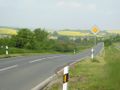
Short before Seeburg. Not to nice weather.
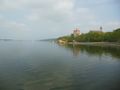
Picture in Seeburg of the Lake.
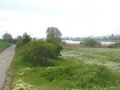
15 minuets later at the other end of the lake.
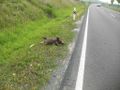
A dead raccoon. It wasn't me, I swear.
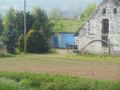
The coordinates are probably inside the shed with the blue door.
50m away from the hash.
My coordinates closest to the hash.
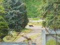
A black cat approaching the hash!


