Difference between revisions of "2014-05-06 50 -113"
From Geohashing
imported>Guzzby (→Photos) |
imported>Guzzby (→Achievements) |
||
| Line 49: | Line 49: | ||
{{#vardefine:ribbonwidth|800px}} | {{#vardefine:ribbonwidth|800px}} | ||
<!-- Add any achievement ribbons you earned below, or remove this section --> | <!-- Add any achievement ribbons you earned below, or remove this section --> | ||
| − | + | {{Land geohash | latitude = 50 | longitude = -113 | date = 2014-03-19 | name = [[User:Guzzby|Guzzby]] }} | |
<!-- =============== USEFUL CATEGORIES FOLLOW ================ | <!-- =============== USEFUL CATEGORIES FOLLOW ================ | ||
Revision as of 22:29, 6 May 2014
| Tue 6 May 2014 in 50,-113: 50.9386013, -113.9962997 geohashing.info google osm bing/os kml crox |
Location
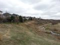
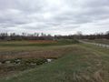
In the community of Douglasdale in Calgary, Alberta Canada. In a field south of the Bow River Pathway
Participants
Plans
I plan to drive over to the geohash. Take a couple of pictures. Then go search for some geocaches in the area.
Expedition
I drove over to the geohash around 11:00 am. I arrived around 11:15 am. I walked down the bow river pathway and then out into the field where the hashpoint is. I took a couple of pictures then left.
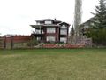
Photos
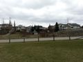
View to the North
View to the East
View to the South
View to the West


Achievements
Guzzby earned the Land geohash achievement
|