Difference between revisions of "2014-05-10 30 -97"
From Geohashing
imported>DODO (Not new anymore ;-)) |
imported>Palmpje m (→Achievements) |
||
| Line 56: | Line 56: | ||
[[Category:Expeditions]] | [[Category:Expeditions]] | ||
[[Category:Expeditions with photos]] | [[Category:Expeditions with photos]] | ||
| + | [[Category:Coordinates not reached]] | ||
[[Category:Not reached - No public access]] | [[Category:Not reached - No public access]] | ||
Revision as of 20:05, 14 May 2014
| Sat 10 May 2014 in 30,-97: 30.3946230, -97.5524217 geohashing.info google osm bing/os kml crox |
Location
Inside a field, by the side of a surprisingly busy rural country road.
Participants
Plans
Make an expedition out of it with some friends and make a semi- road trip out of it as we discover new lands!
Expedition
I was the lone ranger on this trip. The drive was a combination of interesting (winding country roads amongst lush green fields), I-35 which turned into its usual parking lot on Saturdays.
The actual hash turned out to be in the middle of a field by the side of a narrow two lane road (with no shoulders) that had a surprising amount of traffic on it. Stopping would have caused a traffic jam!
Tracklog
Photos
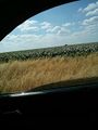
Field containing the actual location. (i've named the file with the wrong format - it was taken May 10th, 2014

Achievements