Difference between revisions of "2014-05-21 49 10"
imported>Schnatterfleck (→Photos) |
imported>Schnatterfleck (→Expedition) |
||
| Line 31: | Line 31: | ||
== Expedition == | == Expedition == | ||
<!-- how it all turned out. your narrative goes here. --> | <!-- how it all turned out. your narrative goes here. --> | ||
| + | I allways wanted to go hunt some hash points. But using the web based tools was allways to complicated. | ||
| + | But this week I discoverd the geohashing app in the Android store - and it works perfectly! :-) | ||
| + | |||
| + | And on this really, really nice day (warm and sunny), it showed me a coordinate that was | ||
| + | - just within reach for me during the 3 or four hours I had to spare (nearly allways going by bike...) | ||
| + | - apparently located only a few meters from a road near an open field | ||
| + | - situated in a really nice rural landscape. | ||
| + | |||
| + | So off I went, leaving work a little early and setting the hash point as a target in my brand new routing software (OSMAnd). | ||
== Tracklog == | == Tracklog == | ||
Revision as of 16:18, 22 May 2014
| Wed 21 May 2014 in 49,10: 49.3687540, 10.8289638 geohashing.info google osm bing/os kml crox |
Location
A wood near Raitersaich
Participants
Plans
Expedition
I allways wanted to go hunt some hash points. But using the web based tools was allways to complicated. But this week I discoverd the geohashing app in the Android store - and it works perfectly! :-)
And on this really, really nice day (warm and sunny), it showed me a coordinate that was - just within reach for me during the 3 or four hours I had to spare (nearly allways going by bike...) - apparently located only a few meters from a road near an open field - situated in a really nice rural landscape.
So off I went, leaving work a little early and setting the hash point as a target in my brand new routing software (OSMAnd).
Tracklog
Photos
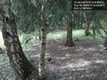
The hashpoint as located by my GPS - surprisingly nice area! Schnatterfleck @49.3688,10.8290
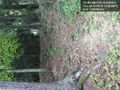
Aeaeah... Routing app?... You're kidding, right...?? @49.4128,10.9025
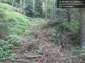
Really steep (more than it looks on the picture)... but also part of the calculated route. Fallback to pushing the bike (at least not carrying yet...) @49.4124,10.9034
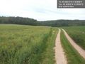
THIS is how I like it :) - But the near dead-end already lurked at the bottom of the little valley.... @49.4095,10.8950
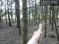
Mission accomplished! @49.3687,10.8288
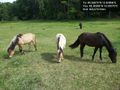
Not very far from the hash point. And I actually know those horses. @49.3699,10.8357
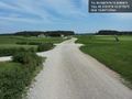
I was actually routed right through the middle of a golf course! @49.3781,10.9775


Achievements