Difference between revisions of "2014-06-01 40 -74"
imported>Zubenelgenubi (Created page with "{{meetup graticule | lat=40 | lon=-74 | date=2014-06-01 }} <!-- edit as necessary --> __NOTOC__ == Participants == *Zubenelgenubi == Plans == This wa...") |
imported>Zubenelgenubi |
||
| Line 14: | Line 14: | ||
== Expedition == | == Expedition == | ||
| − | It was a beautiful day showing Yardville, Bordentown, and Florence/Roebling at their best. I am sure the denizens of the penal facilities I passed in Chesterfield and Bordentown regretted not spending such a nice day at liberty. | + | It was a beautiful day showing Yardville, Bordentown, and Florence/Roebling at their best. I am sure the denizens of the penal facilities I passed in Chesterfield and Bordentown regretted not spending such a nice day at liberty. I capped my first 100-mile biking weekend of the year; crawling to the geohash would have been overkill. |
== Photos == | == Photos == | ||
<gallery> | <gallery> | ||
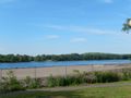
| − | Image:20140601_bas_01. | + | Image:20140601_bas_01.JPG| Crystal Lake and its dam, directly across Route 130 from the geohash. |
| − | Image:20140601_bas_02. | + | Image:20140601_bas_02.JPG| The coordinates are somewhere off in there. |
| − | Image:20140601_bas_03. | + | Image:20140601_bas_03.JPG| Massive wire-tightening wheel from the Roebling works |
| − | Image:20140601_bas_04. | + | Image:20140601_bas_04.JPG| Crucible and other materials outside the Roebling Museum. The original Roebling wire works were in Trenton, expanded down to Roebling when the company began making its own steel. |
| − | Image:20140601_bas_05. | + | Image:20140601_bas_05.JPG| Fieldsboro, a few miles upriver, would be in position to have an excellent view of the landfill and industrial port across the river, but there is basically nowhere that the view is actually accessible. Roebling's city park, high above the Delaware with a remediation project on the shore below, remedies this with great river and landfill views. |
</gallery> | </gallery> | ||
Revision as of 02:34, 3 June 2014
| Sun 1 Jun 2014 in 40,-74: 40.1246731, -74.7440207 geohashing.info google osm bing/os kml crox |
Participants
Plans
This was in a marshy forested area on the Delaware River next to Newbold Island. While it wasn't far from the road, reaching it would nonetheless require getting off Route 130 down a steep slope, trespassing across the River Line rail tracks, and getting across a stream - it wasn't going to happen. But I planned to erase the bad memory of my last bike ride to Roebling (changing a flat tire in 100 degree heat) and take a break to cool off in the Roebling Museum, which showcases the wire manufacturing works which designed the Brooklyn Bridge and built cables for the GWB and Golden Gate among others.
Expedition
It was a beautiful day showing Yardville, Bordentown, and Florence/Roebling at their best. I am sure the denizens of the penal facilities I passed in Chesterfield and Bordentown regretted not spending such a nice day at liberty. I capped my first 100-mile biking weekend of the year; crawling to the geohash would have been overkill.
Photos
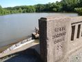
Crystal Lake and its dam, directly across Route 130 from the geohash.
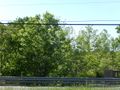
The coordinates are somewhere off in there.
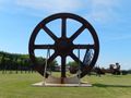
Massive wire-tightening wheel from the Roebling works
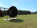
Crucible and other materials outside the Roebling Museum. The original Roebling wire works were in Trenton, expanded down to Roebling when the company began making its own steel.
Fieldsboro, a few miles upriver, would be in position to have an excellent view of the landfill and industrial port across the river, but there is basically nowhere that the view is actually accessible. Roebling's city park, high above the Delaware with a remediation project on the shore below, remedies this with great river and landfill views.


