Difference between revisions of "2014-06-08 62 27"
imported>Mirca |
imported>Mirca |
||
| Line 11: | Line 11: | ||
<!-- what were the original plans --> | <!-- what were the original plans --> | ||
It was sunny Sunday evening. We were driving home from my relatives, and decided to visit the meetup point which was near our route | It was sunny Sunday evening. We were driving home from my relatives, and decided to visit the meetup point which was near our route | ||
| + | |||
| + | == Expedition == | ||
| + | <!-- how it all turned out. your narrative goes here. --> | ||
| + | We were driving from Karttula toward the city of Kuopio. We turned to the road 5550 leading into the village of Haminalahti. We passed the village and turned left to the sand road named Jalkalantie. The road went through the forest and also passed some nice farmhouses. After about 2 km road was paved with very rough gravel. Fortunately we were quite near to the point. We left the car and walked 30 m from the road through the very thick spruce forest. The meetup point was there on a little nice clearing. | ||
| + | We liked it was very easy to get to that hashpoint. It was not so easy to start driving home. The car was on the bumpy ground of the roadside, and it needed some hard pushing before we got it to the road. | ||
| + | |||
| + | == Photos == | ||
| + | <!-- Insert pictures between the gallery tags using the following format: | ||
| + | Image:2012-##-## ## ## Alpha.jpg | Witty Comment | ||
| + | --> | ||
| + | <gallery perrow="5"> | ||
| + | |||
| + | Image:62-27 Point Coordinates.jpg | Success! | ||
| + | Image:The meeting point 8.6.2014 62 27.png | The meeting point in the middle of the clearing | ||
| + | Image:Spruces grow very thickly 8.6.2014 62 27.png | Spruces grow very thickly | ||
| + | Image:The road 8.6.2014 62 27.png | The road with some gravel | ||
| + | |||
| + | </gallery> | ||
Revision as of 20:00, 17 June 2014
Contents
Location
In the thick spruce forest, near the village of Haminalahti. About 20 km from the centrum of Kuopio
Participants
Mirca and her son.
Plans
It was sunny Sunday evening. We were driving home from my relatives, and decided to visit the meetup point which was near our route
Expedition
We were driving from Karttula toward the city of Kuopio. We turned to the road 5550 leading into the village of Haminalahti. We passed the village and turned left to the sand road named Jalkalantie. The road went through the forest and also passed some nice farmhouses. After about 2 km road was paved with very rough gravel. Fortunately we were quite near to the point. We left the car and walked 30 m from the road through the very thick spruce forest. The meetup point was there on a little nice clearing. We liked it was very easy to get to that hashpoint. It was not so easy to start driving home. The car was on the bumpy ground of the roadside, and it needed some hard pushing before we got it to the road.
Photos

Success!

The meeting point in the middle of the clearing
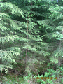
Spruces grow very thickly
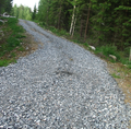
The road with some gravel


