Difference between revisions of "2014-07-08 48 8"
From Geohashing
imported>Ekorren (creating page. Might even finish it before 2016.) |
imported>FippeBot m (Location) |
||
| (4 intermediate revisions by 2 users not shown) | |||
| Line 19: | Line 19: | ||
== Gallery == | == Gallery == | ||
<gallery> | <gallery> | ||
| − | + | 2014-07-08_48_8_5676.JPG|Obligatory Wurmlingen Chapel view | |
| + | 2014-07-08_48_8_5677.JPG|There might be planes! | ||
| + | 2014-07-08_48_8_5682.JPG|There might be wind! | ||
| + | 2014-07-08_48_8_5679.JPG|This is as close as it gets | ||
| + | 2014-07-08_48_8_5678.JPG|The hash field | ||
| + | 2014-07-08_48_8_5680.JPG|Closeup of hash plants | ||
| + | 2014-07-08_48_8_5681.JPG|No planes near the hash | ||
</gallery> | </gallery> | ||
[[Category:Expeditions]] | [[Category:Expeditions]] | ||
| − | |||
[[Category:Expeditions with photos]] | [[Category:Expeditions with photos]] | ||
| − | [[Category:Coordinates reached]] | + | [[Category:Coordinates not reached]] |
| − | - | + | [[Category:Not reached - No public access]] |
| + | {{location|DE|BW|TÜ}} | ||
Latest revision as of 00:39, 15 August 2019
| Tue 8 Jul 2014 in 48,8: 48.5474889, 8.9434451 geohashing.info google osm bing/os kml crox |
Contents
Location
Ammerbuch-Poltringen, a field near the airfield. No planes today, though.
Participants
Ekorren went there by bike
Expedition
I braved some rain (which wasn't as bad as in the morning, though), and went out there by bike. Took a look at and a photo of the crop in the field and left.
Gallery
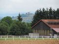
Obligatory Wurmlingen Chapel view
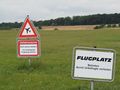
There might be planes!
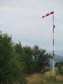
There might be wind!
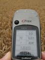
This is as close as it gets
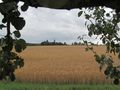
The hash field
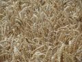
Closeup of hash plants
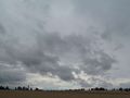
No planes near the hash


