Difference between revisions of "2014-07-20 39 -98"
From Geohashing
imported>Michael5000 m (→Photos) |
imported>Michael5000 m (→Photos) |
||
| Line 38: | Line 38: | ||
--> | --> | ||
<gallery perrow="5"> | <gallery perrow="5"> | ||
| − | File:2014-07-20 39 -98 (1)|I arrive in Downs | + | File:2014-07-20 39 -98 (1).JPG|I arrive in Downs |
| − | File:2014-07-20 39 -98 (2)|There | + | File:2014-07-20 39 -98 (2).JPG|There |
| − | File:2014-07-20 39 -98 (3)|Me | + | File:2014-07-20 39 -98 (3).JPG|Me |
| − | File:2014-07-20 39 -98 (4)|The nearest intersection | + | File:2014-07-20 39 -98 (4).JPG|The nearest intersection |
| − | File:2014-07-20 39 -98 (5)|It was hot | + | File:2014-07-20 39 -98 (5).JPG|It was hot |
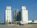
| − | File:2014-07-20 39 -98 (6)|The hashpoint rumbled gently with the noise of nearby grain elevators | + | File:2014-07-20 39 -98 (6).JPG|The hashpoint rumbled gently with the noise of nearby grain elevators |
</gallery> | </gallery> | ||
Revision as of 01:41, 21 July 2014
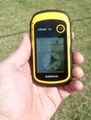
| Sun 20 Jul 2014 in 39,-98: 39.5050784, -98.5392008 geohashing.info google osm bing/os kml crox |
Location
In Downs, Kansas.
Participants
Plans
Michael5000 intends to get to this hashpoint, no matter the cost.
Expedition
Starting from Sidney, Nebraska, I drove east on I-80, then cut back briefly on I-76, went south through eastern Colorado on U.S. 385, drove east back into Nebraska and for quite some distance beyond on U.S. 6, eventually cut off to the south on U.S. 136, then turned south on Nebraska Highway 10, which became Kansas Highway 8 at the state line, continued east on U.S. 36 until turning south on Kansas Highway 181, which got me to the town of Downs. After that, it was easy.
Photos
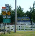
I arrive in Downs
There

Me
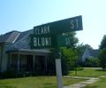
The nearest intersection
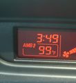
It was hot
The hashpoint rumbled gently with the noise of nearby grain elevators
.JPG)
.JPG)
.JPG)
.JPG)
.JPG)
.JPG)
Achievements