Difference between revisions of "2014-08-03 44 -97"
From Geohashing
imported>GeorgDerReisende (create page) |
imported>FippeBot m (Location) |
||
| (2 intermediate revisions by 2 users not shown) | |||
| Line 1: | Line 1: | ||
| − | |||
| − | |||
| − | |||
| − | |||
| − | |||
| − | |||
| − | |||
| − | |||
| − | |||
| − | |||
{{meetup graticule | {{meetup graticule | ||
| lat=44 | | lat=44 | ||
| Line 15: | Line 5: | ||
}} | }} | ||
| − | + | ||
__NOTOC__ | __NOTOC__ | ||
== Location == | == Location == | ||
| − | + | ||
| + | Line of hay/straw bales southwest of Florence SD | ||
== Participants == | == Participants == | ||
| − | + | ||
| − | + | * [[User:Manicgecko|Manicgecko]] | |
== Plans == | == Plans == | ||
| Line 28: | Line 19: | ||
== Expedition == | == Expedition == | ||
| − | + | ||
| + | Went out to commune with nature. Arrived to quiet area at 1327. Can go to within 150ft of GZ without accessing private property. Able to enjoy the peace until 1347, when the landowners stopped to see if I needed help. Snapped a final picture and thanked them for their courtesy. Not bad for a first visit, not sure if I would enjoy it more with the yahoos I consort with or not. | ||
== Tracklog == | == Tracklog == | ||
| Line 34: | Line 26: | ||
== Photos == | == Photos == | ||
| − | + | ||
| − | + | Will have to find a cheaper camera | |
| − | + | ||
<gallery perrow="5"> | <gallery perrow="5"> | ||
| + | Image:WTNSDHASH1.jpeg | The hashpoint | ||
</gallery> | </gallery> | ||
== Achievements == | == Achievements == | ||
{{#vardefine:ribbonwidth|800px}} | {{#vardefine:ribbonwidth|800px}} | ||
| − | |||
| − | |||
| − | |||
| − | |||
| − | |||
| − | |||
| − | + | * No trespassing | |
| − | |||
| − | |||
| − | |||
| − | |||
| − | |||
[[Category:Expeditions]] | [[Category:Expeditions]] | ||
| − | |||
[[Category:Expeditions with photos]] | [[Category:Expeditions with photos]] | ||
| − | |||
| − | |||
| − | |||
| − | |||
| − | |||
| − | |||
| − | |||
| − | |||
| − | |||
[[Category:Coordinates not reached]] | [[Category:Coordinates not reached]] | ||
| − | |||
| − | |||
| − | |||
| − | |||
| − | |||
[[Category:Not reached - No public access]] | [[Category:Not reached - No public access]] | ||
| − | + | {{location|US|SD|CD}} | |
| − | |||
| − | |||
| − | |||
| − | |||
| − | |||
| − | |||
| − | |||
Latest revision as of 00:56, 15 August 2019
| Sun 3 Aug 2014 in 44,-97: 44.9887592, -97.3096274 geohashing.info google osm bing/os kml crox |
Location
Line of hay/straw bales southwest of Florence SD
Participants
Plans
Expedition
Went out to commune with nature. Arrived to quiet area at 1327. Can go to within 150ft of GZ without accessing private property. Able to enjoy the peace until 1347, when the landowners stopped to see if I needed help. Snapped a final picture and thanked them for their courtesy. Not bad for a first visit, not sure if I would enjoy it more with the yahoos I consort with or not.
Tracklog
Photos
Will have to find a cheaper camera
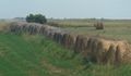
The hashpoint

Achievements
- No trespassing