Difference between revisions of "2014-09-01 53 4"
imported>Eupeodes (→Expedition) |
imported>Eupeodes (→Photos) |
||
| Line 39: | Line 39: | ||
--> | --> | ||
<gallery perrow="5"> | <gallery perrow="5"> | ||
| + | Image:GH_2014-09-01_53_4_cows_1.jpg | Some cute cows | ||
| + | Image:GH_2014-09-01_53_4_cows_2.jpg | A cute cow | ||
| + | Image:GH_2014-09-01_53_4_cows_3.jpg | Another cow | ||
| + | Image:GH_2014-09-01_53_4_proof.jpg | Proof | ||
| + | Image:GH_2014-09-01_53_4_grin.jpg | Grin? | ||
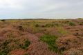
| + | Image:GH_2014-09-01_53_4_view_1.jpg | View | ||
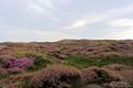
| + | Image:GH_2014-09-01_53_4_view_2.jpg | More view | ||
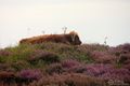
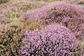
| + | Image:GH_2014-09-01_53_4_heather.jpg | Heather | ||
</gallery> | </gallery> | ||
Revision as of 17:16, 1 September 2014
| Mon 1 Sep 2014 in 53,4: 53.0341211, 4.7300125 geohashing.info google osm bing/os kml crox |
Location
In the dunes of Texel near Den Hoorn.
Participants
- Eupeodes (who has been waiting for ages for this)
Plans
Go for it, will see at what time.
Expedition
I left work early so I would have some time between work and groceries to visit the hash. So I packed my stuff and set of to the hash. At the point where I had planed to park my bike there appeared to be a parking for cars and bikes for people that want to go into the nature. I only had to walk a few hundred meters of which the last 50 were the hardest (because of the vegetation). First I tried to find a easier way around the dense vegetation, but I found my way blocked by some big cows. Also it started to rain. So I walked back to the point from were the distance to the hash was short and walked in. I reached the point, took the pictures and walked back to my bike. From there I went to the supermarket and back home.
Photos
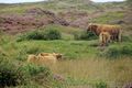
Some cute cows
A cute cow
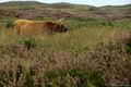
Another cow
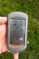
Proof

Grin?
View
More view
Heather


Achievements