Difference between revisions of "2014-09-03 39 -77"
From Geohashing
imported>OfficeLinebacker ([live picture] As close as I was willing to get, [http://www.openstreetmap.org/?lat=39.18740000&lon=-77.42250000&zoom=16&layers=B000FTF @39.1874,-77.4225]) |
imported>OfficeLinebacker ([live picture] dressed like this [http://www.openstreetmap.org/?lat=39.18750000&lon=-77.42240000&zoom=16&layers=B000FTF @39.1875,-77.4224]) |
||
| Line 47: | Line 47: | ||
Image:2014-09-03_39_-77_13-11-39-514.jpg | As close as I was willing to get, [http://www.openstreetmap.org/?lat=39.18740000&lon=-77.42250000&zoom=16&layers=B000FTF @39.1874,-77.4225] | Image:2014-09-03_39_-77_13-11-39-514.jpg | As close as I was willing to get, [http://www.openstreetmap.org/?lat=39.18740000&lon=-77.42250000&zoom=16&layers=B000FTF @39.1874,-77.4225] | ||
| + | |||
| + | Image:2014-09-03_39_-77_13-12-59-202.jpg | dressed like this [http://www.openstreetmap.org/?lat=39.18750000&lon=-77.42240000&zoom=16&layers=B000FTF @39.1875,-77.4224] | ||
</gallery> | </gallery> | ||
Revision as of 17:13, 3 September 2014
| Wed 3 Sep 2014 in 39,-77: 39.1882829, -77.4246731 geohashing.info google osm bing/os kml crox |
Location
In a field in Bealsville, MD. A survey using Google Maps and Google Street View indicates it should be publicly accessible.
Participants
OfficeLinebacker (talk)OfficeLinebacker
Plans
- Going to attempt this. -- OfficeLinebacker (talk) 12:19, 3 September 2014 (EDT)
Going to drive there, maybe get lunch in the area, and drive back.
Expedition
Tracklog
Photos
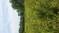
As close as I was willing to get, @39.1874,-77.4225

dressed like this @39.1875,-77.4224


Achievements