Difference between revisions of "2014-09-06 51 4"
imported>Tchakkazulu m (Expedition image.) |
imported>Tchakkazulu (Achievements) |
||
| Line 18: | Line 18: | ||
== Participants == | == Participants == | ||
| − | |||
| − | |||
[[User:Tchakkazulu|Tchakkazulu]] | [[User:Tchakkazulu|Tchakkazulu]] | ||
| Line 29: | Line 27: | ||
I was planning to go to Roosendaal anyway, so it was a nice surprise to see a hash near Zevenbergen. Sadly, it didn't work out at all the way I had hoped. There was some railway work planned near Dordrecht, so from Rotterdam, I had to take a train to Zwijndrecht, then a bus to Lage Zwaluwe, then continue by train to Zevenbergen. | I was planning to go to Roosendaal anyway, so it was a nice surprise to see a hash near Zevenbergen. Sadly, it didn't work out at all the way I had hoped. There was some railway work planned near Dordrecht, so from Rotterdam, I had to take a train to Zwijndrecht, then a bus to Lage Zwaluwe, then continue by train to Zevenbergen. | ||
| − | When there, the walk to the hash was fairly simple. There is a nice walking path around the water that Google maps displays, but OSM doesn't know about, so I enabled tracking on my GPS device | + | When there, the walk to the hash was fairly simple. There is a nice walking path around the water that Google maps displays, but OSM doesn't know about, so I enabled tracking on my GPS device. Took some pictures of the water, the grass, and the trees, and then went back to the train station. |
== Photos == | == Photos == | ||
| Line 47: | Line 45: | ||
{{#vardefine:ribbonwidth|800px}} | {{#vardefine:ribbonwidth|800px}} | ||
<!-- Add any achievement ribbons you earned below, or remove this section --> | <!-- Add any achievement ribbons you earned below, or remove this section --> | ||
| + | {{land geohash | ||
| + | | latitude = 51 | ||
| + | | longitude = 4 | ||
| + | | date = 2014-09-06 | ||
| + | | name = Tchakkazulu | ||
| + | | image = 2014_09_06_51_4_Photo05_Coords2.jpg | ||
| + | }} | ||
| + | {{OpenStreetMap achievement | ||
| + | | latitude = 51 | ||
| + | | longitude = 4 | ||
| + | | date = 2014-09-06 | ||
| + | | OSMlink = 25297536 | ||
| + | | OSMlink2 = 25297811 | ||
| + | | name = Tchakkazulu | ||
| + | | image = 2014_09_06_51_4_Photo06_Path.jpg | ||
| + | }} | ||
<!-- =============== USEFUL CATEGORIES FOLLOW ================ | <!-- =============== USEFUL CATEGORIES FOLLOW ================ | ||
| − | |||
| − | |||
| − | |||
| − | |||
[[Category:Expeditions]] | [[Category:Expeditions]] | ||
[[Category:Expeditions with photos]] | [[Category:Expeditions with photos]] | ||
[[Category:Coordinates reached]] | [[Category:Coordinates reached]] | ||
Revision as of 00:46, 8 September 2014

| Sat 6 Sep 2014 in 51,4: 51.6391881, 4.5978058 geohashing.info google osm bing/os kml crox |
Location
Zevenbergen, Noord Brabant. It looks accessible enough on Google maps.
Participants
Plans
Tchakkazulu is currently on the train from Utrecht to Rotterdam. He'll then take a train to Zevenbergen, hop out, hopefully visit the hash, take some crappy pictures, and continue his journey to the south.
Expedition
I was planning to go to Roosendaal anyway, so it was a nice surprise to see a hash near Zevenbergen. Sadly, it didn't work out at all the way I had hoped. There was some railway work planned near Dordrecht, so from Rotterdam, I had to take a train to Zwijndrecht, then a bus to Lage Zwaluwe, then continue by train to Zevenbergen.
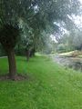
When there, the walk to the hash was fairly simple. There is a nice walking path around the water that Google maps displays, but OSM doesn't know about, so I enabled tracking on my GPS device. Took some pictures of the water, the grass, and the trees, and then went back to the train station.
Photos
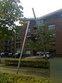
A statue between the station and the hash.
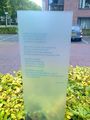
Poem next to the statue.
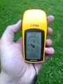
Coordinates: reached!
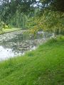
Water near the hash.
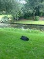
My bag at the coordinates.
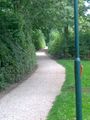
The path going all the way around the water.
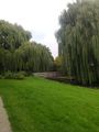
Nice grassy area.
Bridge across the water, into residential area.
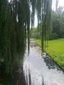
View from the bridge, mostly blocked by willows.


Achievements
Tchakkazulu earned the Land geohash achievement
|
Tchakkazulu earned the OpenStreetMap achievement
|