Difference between revisions of "2014-11-22 43 -86"
imported>IronAngel |
imported>CO2 (This is how you add images - but apparently you're not being notified if people say your name in chat) |
||
| Line 37: | Line 37: | ||
Image:2012-##-## ## ## Alpha.jpg | Witty Comment | Image:2012-##-## ## ## Alpha.jpg | Witty Comment | ||
--> | --> | ||
| − | <gallery perrow="5">Image | + | <gallery perrow="5"> |
| + | Image:IronAngel_First_geohash.jpg | Composite image of my silly grin and a photo of the hash point overlaid on the Google Satellite photo of the hash point. | ||
| + | Image:Geohash for 22 nov 2014 route.jpg | Text here | ||
</gallery> | </gallery> | ||
Revision as of 23:16, 22 November 2014
| Sat 22 Nov 2014 in 43,-86: 43.7102331, -86.3570493 geohashing.info google osm bing/os kml crox |
Location
43.710233°, -86.35705°
- At the North-East corner of Lake Road and N. Oceana Drive - located within a few feet of the drainage culvert.
Participants
- 2014-11-22: IronAngel visited the corner.
Plans
The original plan I had in mind was to walk to the hashpoint, as it is about 2850-2950 feet from my front door in a straight line, however the lake in the way made the trip a bit longer, and the cold rain encouraged use of a car.
Expedition
I arrived at 4:31pm after a one minute drive (edit, it was probably more like three or four - it was a bit slick). As I rounded the corner I easily spotted the ditch I had noted in the google satellite photo, and parked the car. The rain had cleared most of the snow, making walking in to its location about 15 feet off the road much easier. At the hashpoint I found a drainage culvert, withing a few feet of the hash judging by the image printed out from the satellite photo. Photos taken of the hash point (with an unneeded compass, but hey, I have it in my hiking jacket pocket anyway!), I returned home. My first successful hash!!
Tracklog
Photos
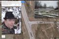
Composite image of my silly grin and a photo of the hash point overlaid on the Google Satellite photo of the hash point.
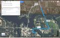
Text here


Achievements
Land Geohash
Couch Potato - honorary mention
No Batteries Geohash