Difference between revisions of "2014-12-04 53 9"
imported>Jevanyn m |
m |
||
| (2 intermediate revisions by 2 users not shown) | |||
| Line 1: | Line 1: | ||
| − | |||
| − | |||
| − | |||
| − | |||
| − | |||
| − | |||
| − | |||
| − | |||
| − | |||
| − | |||
{{meetup graticule | {{meetup graticule | ||
| lat=53 | | lat=53 | ||
| Line 15: | Line 5: | ||
}} | }} | ||
| − | |||
__NOTOC__ | __NOTOC__ | ||
== Location == | == Location == | ||
| Line 27: | Line 16: | ||
== Expedition == | == Expedition == | ||
| − | + | [[User:Koryu|Koryu]]: As promised, I went there by car after work and drove by car on a dirt road the closest to the geohash. There was a woman with a dog passing by wondering what I did there standing around, taking pictures. Unfortunately they didn't turn out well, because it was already dark.<br> | |
| − | + | I consider the expedition a success, even though I didn't reach the hash exactly, because I like driving off the beaten path and see what there is to discover. Even if it's just a dirt road, some trees and a dog leading it's human friend to the next territorial mark. | |
| − | |||
| − | |||
== Photos == | == Photos == | ||
| − | |||
| − | |||
| − | |||
<gallery perrow="5"> | <gallery perrow="5"> | ||
| + | Image:2014-12-04 53 9 navi.jpg | My way from work as seen on my satnav. | ||
| + | Image:2014-12-04 53 9 ghApp.png | That's how close I was to the hash seen from the Geohashing app. | ||
| + | Image:2014-12-04 53 9 night.jpg | A dark picture of the road in front of my car. | ||
</gallery> | </gallery> | ||
| − | |||
| − | |||
| − | |||
| − | |||
| − | |||
| − | |||
| − | |||
| − | |||
| − | |||
| − | |||
| − | |||
| − | |||
| − | |||
[[Category:Expeditions]] | [[Category:Expeditions]] | ||
| − | |||
[[Category:Expeditions with photos]] | [[Category:Expeditions with photos]] | ||
| − | |||
| − | |||
| − | |||
| − | |||
| − | |||
| − | |||
| − | |||
| − | |||
| − | |||
[[Category:Coordinates not reached]] | [[Category:Coordinates not reached]] | ||
| − | + | [[Category:Not reached - Unknown]] | |
| − | + | {{location|DE|SH|PI}} | |
| − | |||
| − | |||
| − | |||
| − | |||
| − | |||
| − | |||
| − | [[Category:Not reached - | ||
| − | |||
| − | |||
| − | |||
| − | |||
| − | |||
Latest revision as of 18:04, 28 March 2022
| Thu 4 Dec 2014 in 53,9: 53.7328422, 9.9270106 geohashing.info google osm bing/os kml crox |
Location
On a meadow near Quickborn.
Participants
Plans
Koryu will go there between work and band rehearsal and be there around 1900. Will not stay long because of limited time though. He'll go as close as possible by car and take the rest by feet, if it's not to wet.
Expedition
Koryu: As promised, I went there by car after work and drove by car on a dirt road the closest to the geohash. There was a woman with a dog passing by wondering what I did there standing around, taking pictures. Unfortunately they didn't turn out well, because it was already dark.
I consider the expedition a success, even though I didn't reach the hash exactly, because I like driving off the beaten path and see what there is to discover. Even if it's just a dirt road, some trees and a dog leading it's human friend to the next territorial mark.
Photos
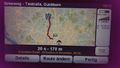
My way from work as seen on my satnav.
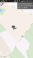
That's how close I was to the hash seen from the Geohashing app.

A dark picture of the road in front of my car.


