Difference between revisions of "2014-12-06 44 -123"
From Geohashing
imported>FippeBot m (Location) |
m |
||
| Line 46: | Line 46: | ||
[[Category:Expeditions]] | [[Category:Expeditions]] | ||
[[Category:Expeditions with photos]] | [[Category:Expeditions with photos]] | ||
| + | [[Category:Coordinates not reached]] | ||
[[Category:Not reached - No public access]] | [[Category:Not reached - No public access]] | ||
{{location|US|OR|PO}} | {{location|US|OR|PO}} | ||
Latest revision as of 09:18, 12 September 2021
| Sat 6 Dec 2014 in 44,-123: 44.7973598, -123.4507040 geohashing.info google osm bing/os kml crox |
Location
A logging forest in Polk County, Oregon, U.S.A.
Participants
- Frogman
- Alison
- Kyle
Plans
We planned on hitting this point early in the morning, as we all had pen-and-paper roleplaying game obligations later in the day.
Expedition
It was a pretty drive, full of raisins and missed turns. We pulled off on a charming rural road to head to the point, but unfortunately the latter half had giant "Private Property" signs warning not to proceed unless we wanted to risk having the gate closed on us. We decided to turn back.
Tracklog
Photos
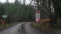
We go no further!

We still had a good time.

