Difference between revisions of "2015-02-21 48 8"
From Geohashing
imported>RecentlyChanged ([live picture] All the grinning people! [http://www.openstreetmap.org/?lat=48.22209477&lon=8.24508905&zoom=16&layers=B000FTF @48.2221,8.2451]) |
imported>RecentlyChanged |
||
| Line 15: | Line 15: | ||
}} | }} | ||
| − | + | ||
| − | |||
| − | |||
| − | |||
== Participants == | == Participants == | ||
| − | + | [[User:RecentlyChanged|RecentlyChanged]] ([[User_talk:RecentlyChanged|talk]]), my sisters and Freeeeef | |
| − | |||
== Plans == | == Plans == | ||
| − | + | *My sisters asked for something to do, I've instantly got an idea! Now on our way. -- [[User:RecentlyChanged|RecentlyChanged]] ([[User_talk:RecentlyChanged|talk]]) 16:14, 21 February 2015 (CET) | |
| + | |||
| + | There wasn't much of a plan, except we thought it would be cold and with a lot of snow, so we took our sleds with us. | ||
== Expedition == | == Expedition == | ||
| − | + | We drove near the Hashpoint, from where we walked the few hundred meters. It wasn't a really hard geohash, but it was fun, because it was warm and the landscape was nice, we had quite a nice view through the trees. | |
== Tracklog == | == Tracklog == | ||
| − | + | http://www.everytrail.com/view_trip.php?trip_id=3098126 | |
== Photos == | == Photos == | ||
| Line 44: | Line 42: | ||
== Achievements == | == Achievements == | ||
{{#vardefine:ribbonwidth|800px}} | {{#vardefine:ribbonwidth|800px}} | ||
| − | |||
| − | |||
| − | |||
| − | |||
| − | |||
| − | |||
| − | |||
| − | |||
| − | |||
| − | |||
| − | |||
| − | |||
| − | |||
[[Category:Expeditions]] | [[Category:Expeditions]] | ||
| − | |||
[[Category:Expeditions with photos]] | [[Category:Expeditions with photos]] | ||
| − | |||
| − | |||
| − | |||
| − | |||
| − | |||
| − | |||
| − | |||
| − | |||
| − | |||
| − | |||
| − | |||
| − | |||
| − | |||
| − | |||
| − | |||
| − | |||
| − | |||
| − | |||
| − | |||
| − | |||
| − | |||
| − | |||
| − | |||
| − | |||
| − | |||
| − | |||
| − | |||
Revision as of 09:07, 2 March 2015
| Sat 21 Feb 2015 in 48,8: 48.2219379, 8.2449723 geohashing.info google osm bing/os kml crox |
Participants
RecentlyChanged (talk), my sisters and Freeeeef
Plans
- My sisters asked for something to do, I've instantly got an idea! Now on our way. -- RecentlyChanged (talk) 16:14, 21 February 2015 (CET)
There wasn't much of a plan, except we thought it would be cold and with a lot of snow, so we took our sleds with us.
Expedition
We drove near the Hashpoint, from where we walked the few hundred meters. It wasn't a really hard geohash, but it was fun, because it was warm and the landscape was nice, we had quite a nice view through the trees.
Tracklog
http://www.everytrail.com/view_trip.php?trip_id=3098126
Photos
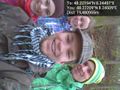
All the grinning people! @48.2221,8.2451
