Difference between revisions of "2015-03-08 37 -122"
imported>Codae |
imported>FippeBot m (Location) |
||
| (2 intermediate revisions by one other user not shown) | |||
| Line 10: | Line 10: | ||
--> | --> | ||
{{meetup graticule | {{meetup graticule | ||
| − | | lat= | + | | lat=37 |
| − | | lon=- | + | | lon=-122 |
| − | | date= | + | | date=2015-03-08 |
}} | }} | ||
| Line 19: | Line 19: | ||
== Location == | == Location == | ||
<!-- where you've surveyed the hash to be --> | <!-- where you've surveyed the hash to be --> | ||
| + | In a front garden in El Cerrito, California. | ||
== Participants == | == Participants == | ||
<!-- who attended: If you link to your wiki user name in this section, your expedition will be picked up by the various statistics generated for geohashing. You may use three tildes ~ as a shortcut to automatically insert the user signature of the account you are editing with. | <!-- who attended: If you link to your wiki user name in this section, your expedition will be picked up by the various statistics generated for geohashing. You may use three tildes ~ as a shortcut to automatically insert the user signature of the account you are editing with. | ||
--> | --> | ||
| + | [[User:Codae|Codae]] | ||
== Plans == | == Plans == | ||
<!-- what were the original plans --> | <!-- what were the original plans --> | ||
| + | The hashpoint was clearly on private property. I called ahead the night before to a phone number I obtained by Googling the address, but all I got was a "full inbox" message. So I decided to take the bus up to the house and get permission on site. | ||
== Expedition == | == Expedition == | ||
<!-- how it all turned out. your narrative goes here. --> | <!-- how it all turned out. your narrative goes here. --> | ||
| + | I got to the lot frontage without incident. Even from the cul-de-sac, there's a great view over the front fence and the house itself across San Francisco Bay. | ||
| + | |||
| + | I couldn't enter the property due to fencing, and I got no reply when I pressed the "call" buttons on the electronic locks for the gates (one pedestrian, one automotive). But someone was mowing the side yard, so I decided to wait around until I caught someone's attention. | ||
| + | |||
| + | The attention came from a couple of large golden dogs, who after the lawnmower was shut off ran up to the gate, barking loudly. A man followed behind. I asked permission to enter the front yard "to take some pictures", and his response was (to the best of my recollection), | ||
| + | |||
| + | "No. Definitely no. Sorry." | ||
| + | |||
| + | I thus apologized for his time and retreated to the other side of the cul-de-sac to get some documentary photographs. | ||
| + | |||
| + | I had a short wait at the bus stop for the return trip. I observed that it comprised a memorial to, I presume, two deceased residents. It was equipped with a brick giving latitude, longitude, and altitude; according to my GPS, the former read about a second too far north. I didn't have time to do the math to check the other two (my GPS reports in milliminutes, and the monument is in seconds). | ||
== Tracklog == | == Tracklog == | ||
| Line 38: | Line 52: | ||
--> | --> | ||
<gallery perrow="5"> | <gallery perrow="5"> | ||
| + | Image:2015-03-08 37 -122 View.jpg | The fence that stymied me, with an inadequate-contrast view of the Bay and its margins beyond. | ||
| + | Image:2015-03-08 37 -122 Proof.jpg | Coordinates from the other side of the cul-de-sac: not my closest point, but in the general vicinity. | ||
| + | Image:2015-03-08 37 -122 Brick.jpg | A self-marking landmark. | ||
</gallery> | </gallery> | ||
| Line 43: | Line 60: | ||
{{#vardefine:ribbonwidth|800px}} | {{#vardefine:ribbonwidth|800px}} | ||
<!-- Add any achievement ribbons you earned below, or remove this section --> | <!-- Add any achievement ribbons you earned below, or remove this section --> | ||
| + | {{No trespassing|latitude=37|longitude=-122|date=2015-03-08|name=Codae}} | ||
<!-- =============== USEFUL CATEGORIES FOLLOW ================ | <!-- =============== USEFUL CATEGORIES FOLLOW ================ | ||
Delete the next line ONLY if you have chosen the appropriate categories below. If you are unsure, don't worry. People will read your report and help you with the classification.--> | Delete the next line ONLY if you have chosen the appropriate categories below. If you are unsure, don't worry. People will read your report and help you with the classification.--> | ||
| − | |||
<!-- ==REQUEST FOR TWITTER BOT== Please leave either the New report or the Expedition planning category in as long as you work on it. This helps the twitter bot a lot with announcing the right outcome at the right moment. --> | <!-- ==REQUEST FOR TWITTER BOT== Please leave either the New report or the Expedition planning category in as long as you work on it. This helps the twitter bot a lot with announcing the right outcome at the right moment. --> | ||
<!-- Potential categories. Please include all the ones appropriate to your expedition --> | <!-- Potential categories. Please include all the ones appropriate to your expedition --> | ||
| − | |||
| − | |||
| − | |||
| − | + | ||
[[Category:Expeditions]] | [[Category:Expeditions]] | ||
| − | + | ||
[[Category:Expeditions with photos]] | [[Category:Expeditions with photos]] | ||
| − | |||
| − | |||
| − | |||
| − | |||
| − | |||
| − | |||
| + | [[Category:Coordinates not reached]] | ||
| − | |||
| − | |||
| − | |||
| − | |||
| − | |||
| − | |||
| − | |||
[[Category:Not reached - No public access]] | [[Category:Not reached - No public access]] | ||
| − | + | {{location|US|CA|CN}} | |
| − | |||
| − | |||
| − | |||
| − | |||
| − | |||
| − | |||
| − | |||
Latest revision as of 02:58, 15 August 2019
| Sun 8 Mar 2015 in 37,-122: 37.9223329, -122.2975105 geohashing.info google osm bing/os kml crox |
Location
In a front garden in El Cerrito, California.
Participants
Plans
The hashpoint was clearly on private property. I called ahead the night before to a phone number I obtained by Googling the address, but all I got was a "full inbox" message. So I decided to take the bus up to the house and get permission on site.
Expedition
I got to the lot frontage without incident. Even from the cul-de-sac, there's a great view over the front fence and the house itself across San Francisco Bay.
I couldn't enter the property due to fencing, and I got no reply when I pressed the "call" buttons on the electronic locks for the gates (one pedestrian, one automotive). But someone was mowing the side yard, so I decided to wait around until I caught someone's attention.
The attention came from a couple of large golden dogs, who after the lawnmower was shut off ran up to the gate, barking loudly. A man followed behind. I asked permission to enter the front yard "to take some pictures", and his response was (to the best of my recollection),
"No. Definitely no. Sorry."
I thus apologized for his time and retreated to the other side of the cul-de-sac to get some documentary photographs.
I had a short wait at the bus stop for the return trip. I observed that it comprised a memorial to, I presume, two deceased residents. It was equipped with a brick giving latitude, longitude, and altitude; according to my GPS, the former read about a second too far north. I didn't have time to do the math to check the other two (my GPS reports in milliminutes, and the monument is in seconds).
Tracklog
Photos
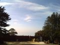
The fence that stymied me, with an inadequate-contrast view of the Bay and its margins beyond.
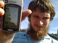
Coordinates from the other side of the cul-de-sac: not my closest point, but in the general vicinity.
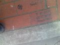
A self-marking landmark.


Achievements
Codae earned the No trespassing consolation prize
|