Difference between revisions of "2015-04-12 54 -2"
From Geohashing
imported>Angel (An expedition message sent via Geohash Droid for Android.) |
imported>FippeBot m (Location) |
||
| (3 intermediate revisions by one other user not shown) | |||
| Line 19: | Line 19: | ||
== Location == | == Location == | ||
<!-- where you've surveyed the hash to be --> | <!-- where you've surveyed the hash to be --> | ||
| + | Near Blea Tarn Reservoir, outside Lancaster. | ||
== Participants == | == Participants == | ||
<!-- who attended: If you link to your wiki user name in this section, your expedition will be picked up by the various statistics generated for geohashing. You may use three tildes ~ as a shortcut to automatically insert the user signature of the account you are editing with. | <!-- who attended: If you link to your wiki user name in this section, your expedition will be picked up by the various statistics generated for geohashing. You may use three tildes ~ as a shortcut to automatically insert the user signature of the account you are editing with. | ||
--> | --> | ||
| + | * [[User:Angel|Angel]] ([[User talk:Angel|talk]]) | ||
== Plans == | == Plans == | ||
| Line 38: | Line 40: | ||
--> | --> | ||
<gallery perrow="5"> | <gallery perrow="5"> | ||
| + | |||
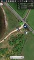
| + | Image:2015-04-12_54_-2_angel_1428840936022.jpg | Best distance: 75 feet. Looks like this is as near as I go. [http://www.openstreetmap.org/?lat=54.01960000&lon=-2.77062000&zoom=16&layers=B000FTF @54.0196,-2.7706] | ||
| + | |||
| + | Image:2015-04-12_54_-2_angel_1428840852000.jpg | | ||
</gallery> | </gallery> | ||
| Line 45: | Line 51: | ||
| − | |||
| − | |||
| − | |||
| − | |||
| − | |||
| − | |||
| − | |||
| − | |||
| − | |||
| − | |||
[[Category:Expeditions]] | [[Category:Expeditions]] | ||
| − | |||
[[Category:Expeditions with photos]] | [[Category:Expeditions with photos]] | ||
| − | |||
| − | |||
| − | |||
| − | |||
| − | |||
| − | |||
| + | [[Category:Coordinates not reached]] | ||
| − | |||
| − | |||
| − | |||
| − | |||
| − | |||
| − | |||
| − | |||
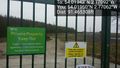
[[Category:Not reached - No public access]] | [[Category:Not reached - No public access]] | ||
| − | + | {{location|GB|ENG|LAN}} | |
| − | |||
| − | |||
| − | |||
| − | |||
| − | |||
| − | |||
| − | |||
Latest revision as of 03:19, 15 August 2019
| Sun 12 Apr 2015 in 54,-2: 54.0194212, -2.7709179 geohashing.info google osm bing/os kml crox |
Location
Near Blea Tarn Reservoir, outside Lancaster.
Participants
Plans
Expedition
Tracklog
Photos
Best distance: 75 feet. Looks like this is as near as I go. @54.0196,-2.7706