Difference between revisions of "2015-05-14 51 4"
imported>FelixTheCat m |
imported>FelixTheCat |
||
| Line 24: | Line 24: | ||
== Photos == | == Photos == | ||
| − | |||
| − | |||
| − | |||
<gallery perrow="5"> | <gallery perrow="5"> | ||
| + | Image:2015-05-14 51 4 FelixTheCat 1.JPG | Beautiful sunny day in the polders south of Delft. | ||
| + | Image:2015-05-14 51 4 FelixTheCat 2.JPG | The Benelux Tunnel contains the first bike path I've ever seen that actually has a speed limit! | ||
| + | Image:2015-05-14 51 4 FelixTheCat 3.JPG | This company specializes in tanker containers. Custom paintjobs available :-) | ||
| + | Image:2015-05-14 51 4 FelixTheCat 4.JPG | Entering a nature reserve. Acces prohibited to areas outside the footpaths... | ||
| + | Image:2015-05-14 51 4 FelixTheCat 5.JPG | There was this funny thingamabob to cross a stream. I'm sure such a device has an official name, but I'm no expert in stream crossing equipment. | ||
| + | Image:2015-05-14 51 4 FelixTheCat 6.JPG | Alas, the hash was located about 200 m off the footpath. But even if it was allowed, it would have been very difficult to reach without wading through deep water. | ||
| + | Image:2015-05-14 51 4 FelixTheCat 7.JPG | Another type of stream crossing device. Again, I'm no expert, but I believe this type is called a "bridge". | ||
| + | Image:2015-05-14 51 4 FelixTheCat 8.JPG | A bit furter on there was this interesting-looking watchtower. | ||
| + | Image:2015-05-14 51 4 FelixTheCat 9.JPG | Lloy looking towards the hash from said tower. | ||
| + | Image:2015-05-14 51 4 FelixTheCat 10.JPG | The last picture I ever took of my bike :-( If you see it anywhere, please drop me a line! | ||
</gallery> | </gallery> | ||
Revision as of 20:47, 19 May 2015
| Thu 14 May 2015 in 51,4: 51.7934498, 4.2355887 geohashing.info google osm bing/os kml crox |
Location
Somewhere in Beningerslikken Nature Reserve, south of Zuidland.
Participants
Plans
Bike there and see if the hash is accessible.
Expedition
Today was Ascension Day, which is a national holiday in this country, so I figured it was a good day to go for a nice long bike ride. Today's hash was about 35 km from my house, and the weather was nice. I wasn't sure if the hash would be accessible, because the whole area looked like some construction project on Google Maps.
I left Delft heading South. Riding about 10 km through the polders I reached Schiedam, and used the Benelux Tunnel to cross the Nieuwe Maas. Reaching Pernis with all its petrochemical equipment, I headed West towards Spijkenisse, then turned South towards Zuidland. Passing this village, there was only farmland left for the rest of the island, until I reached the Beningerslikken Nature Rserve. Parking my bike at the entrance I walked the last part towards the hash. Unfortunately, the point itself was not reachable because it was in the middle of a very wet area, and it's prohibited to venture outside the footpaths. Still, it was a very nice trip through some very pretty places.
This was also the last trip I'm likely to ever make on my beloved Silver Giant, because it was stolen later that evening ;-(
Photos
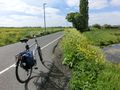
Beautiful sunny day in the polders south of Delft.
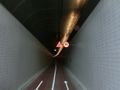
The Benelux Tunnel contains the first bike path I've ever seen that actually has a speed limit!
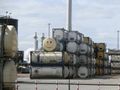
This company specializes in tanker containers. Custom paintjobs available :-)
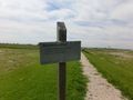
Entering a nature reserve. Acces prohibited to areas outside the footpaths...
There was this funny thingamabob to cross a stream. I'm sure such a device has an official name, but I'm no expert in stream crossing equipment.
Alas, the hash was located about 200 m off the footpath. But even if it was allowed, it would have been very difficult to reach without wading through deep water.
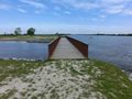
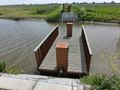
Another type of stream crossing device. Again, I'm no expert, but I believe this type is called a "bridge".
A bit furter on there was this interesting-looking watchtower.
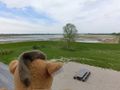
Lloy looking towards the hash from said tower.
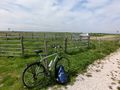
The last picture I ever took of my bike :-( If you see it anywhere, please drop me a line!


