Difference between revisions of "2015-07-23 49 8"
From Geohashing
imported>Tads |
imported>FippeBot m (Location) |
||
| (2 intermediate revisions by 2 users not shown) | |||
| Line 30: | Line 30: | ||
== Photos == | == Photos == | ||
| − | < | + | <gallery perrow="4"> |
| − | Image: | + | Image:tads_2015-07-23_49_8_approaching1.jpg | Approaching the hashpoint which lies close to the wind turbines in the distance. |
| − | -- | + | Image:tads_2015-07-23_49_8_approaching2.jpg | Getting closer... |
| − | + | Image:tads_2015-07-23_49_8_approaching3.jpg | ...and closer... | |
| + | Image:tads_2015-07-23_49_8_fences.jpg | ...almost there, but fences block my way. | ||
| + | Image:tads_2015-07-23_49_8_kuckucksweg.jpg | Following the 'Kuckucksweg' hiking trail for a few hundred meters. | ||
| + | Image:tads_2015-07-23_49_8_view-west.jpg | Panoramic view across the fields. | ||
| + | Image:tads_2015-07-23_49_8_windturbines.jpg | The wind turbines are very close now. | ||
| + | Image:tads_2015-07-23_49_8_view.jpg | Panoramic view into the valley. | ||
</gallery> | </gallery> | ||
| Line 40: | Line 45: | ||
<!-- Add any achievement ribbons you earned below, or remove this section --> | <!-- Add any achievement ribbons you earned below, or remove this section --> | ||
| − | |||
| − | |||
[[Category:Expeditions]] | [[Category:Expeditions]] | ||
<!-- [[Category:Expeditions with photos]] --> | <!-- [[Category:Expeditions with photos]] --> | ||
[[Category:Coordinates not reached]] | [[Category:Coordinates not reached]] | ||
[[Category:Not reached - No public access]] | [[Category:Not reached - No public access]] | ||
| + | {{location|DE|HE|DA}} | ||
Latest revision as of 04:27, 15 August 2019
| Thu 23 Jul 2015 in 49,8: 49.8774214, 8.9706540 geohashing.info google osm bing/os kml crox |
Location
The hashpoint was located on a field in Raibach, close to Groß-Umstadt.
Participants
Plans
- Tads (talk) plans to ride his bike to the Hashpoint in the morning or around lunchtime -- Tads (talk) 19:31, 22 July 2015 (EDT)
My plan was to get to the hashpoint by bike, which is roughly a 27km ride each way. Option of taking the train back from Dieburg, Reinheim or so.
Expedition
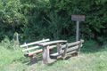
- Here a fence, there a fence, everywhere a fence fence.
Giving up :-( -- Tads (talk) @49.8773,8.9636 12:43, 23 July 2015 (GMT+02:00)
While searching for a path to the field, I came across the Kuckucksweg, a local hiking trail.
Photos
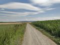
Approaching the hashpoint which lies close to the wind turbines in the distance.
Getting closer...
...and closer...
...almost there, but fences block my way.
Following the 'Kuckucksweg' hiking trail for a few hundred meters.
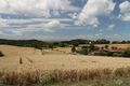
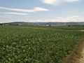
Panoramic view across the fields.
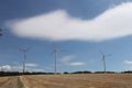
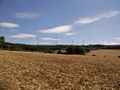
The wind turbines are very close now.
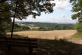
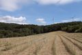
Panoramic view into the valley.


