Difference between revisions of "2015-08-22 42 -78"
imported>Pedalpusher (New report) |
imported>FippeBot m (Location) |
||
| (2 intermediate revisions by one other user not shown) | |||
| Line 9: | Line 9: | ||
== Expedition == | == Expedition == | ||
I knew this was on private property from the satellite view, but it was almost right on a route I normally ride my bike. I decided to ride over anyway and add another expedition to my posted achievement. | I knew this was on private property from the satellite view, but it was almost right on a route I normally ride my bike. I decided to ride over anyway and add another expedition to my posted achievement. | ||
| + | |||
| + | Nothing really to report for this as I stopped in front of the driveway and got some pictures. Although, I did record my highest speed on my bike at 51 MPH (82 KPH) going down the hill right after the hash. It had a few very steep sections and was quite curvy so I was being careful on the first part as I wasn't familiar with the road. Getting toward the bottom, I could see the last section and a long straight bit before I had to stop so it was here where I got to see how fast I could go. | ||
== Photos == | == Photos == | ||
| − | |||
<gallery perrow="5"> | <gallery perrow="5"> | ||
| − | Image: | + | Image: 2015-08-22 closeToHash.jpg | I arrived at the driveway. |
| − | Image: | + | Image: 2015-08-22 lookingTowardHash.jpg | But the hash is behind the house in the brush. |
| − | Image: | + | Image: 2015-08-22 gps.jpg | Distance to the hash. |
| − | Image: | + | Image: 2015-08-22 gps2.jpg | Location info. |
| − | |||
| − | |||
| − | |||
| − | |||
</gallery> | </gallery> | ||
== Ribbons == | == Ribbons == | ||
| − | + | {{bicycle geohash | |
| + | | latitude = 42 | ||
| + | | longitude = -78 | ||
| + | | date = 2015-08-22 | ||
| + | | name = Pedalpusher | ||
| + | | distance = just over 11 miles | ||
| + | }} | ||
| + | {{No trespassing | ||
| + | | latitude = 42 | ||
| + | | longitude = -78 | ||
| + | | date = 2015-08-22 | ||
| + | | name = Pedalpusher | ||
| + | | distance = 320 Feet | ||
| + | }} | ||
| + | {{gratuitous ribbon | ||
| + | | color = maroon | ||
| + | | icon = Bikefast.png | ||
| + | | latitude = 42 | ||
| + | | longitude = -78 | ||
| + | | date = 2015-08-22 | ||
| + | | achievement = Bicycle Speed Record | ||
| + | | description = setting a personal speed record on the bike, hitting 51 MPH downhill near the | ||
| + | | name = Pedalpusher | ||
| + | }} | ||
| + | |||
| − | |||
[[Category:Expeditions]] | [[Category:Expeditions]] | ||
[[Category:Coordinates not reached]] | [[Category:Coordinates not reached]] | ||
[[Category:Not reached - No public access]] | [[Category:Not reached - No public access]] | ||
| + | {{location|US|NY|ER}} | ||
Latest revision as of 04:52, 15 August 2019
| Sat 22 Aug 2015 in 42,-78: 42.6552329, -78.7231957 geohashing.info google osm bing/os kml crox |
Location
Private property on Liebler Rd
Participants
Expedition
I knew this was on private property from the satellite view, but it was almost right on a route I normally ride my bike. I decided to ride over anyway and add another expedition to my posted achievement.
Nothing really to report for this as I stopped in front of the driveway and got some pictures. Although, I did record my highest speed on my bike at 51 MPH (82 KPH) going down the hill right after the hash. It had a few very steep sections and was quite curvy so I was being careful on the first part as I wasn't familiar with the road. Getting toward the bottom, I could see the last section and a long straight bit before I had to stop so it was here where I got to see how fast I could go.
Photos
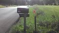
I arrived at the driveway.
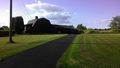
But the hash is behind the house in the brush.

Distance to the hash.

Location info.


Ribbons
Pedalpusher earned the Bicycle geohash achievement
|
Pedalpusher earned the No trespassing consolation prize
|
Pedalpusher earned the Bicycle Speed Record
|