Difference between revisions of "2015-09-11 39 -75"
imported>FippeBot m (Location) |
m |
||
| Line 52: | Line 52: | ||
{{No trespassing |latitude=39 |longitude=-75 |date=2015-09-11 |image= |name= [[User:Subotai45|Mitchell]] and [[User:Mason|Mason]]|distance= }} | {{No trespassing |latitude=39 |longitude=-75 |date=2015-09-11 |image= |name= [[User:Subotai45|Mitchell]] and [[User:Mason|Mason]]|distance= }} | ||
| − | |||
| − | |||
| − | |||
| − | |||
| − | |||
| − | |||
| − | |||
| − | |||
| − | |||
| − | |||
| − | |||
[[Category:Expeditions]] | [[Category:Expeditions]] | ||
| − | |||
[[Category:Expeditions with photos]] | [[Category:Expeditions with photos]] | ||
| − | |||
| − | |||
| − | |||
| − | |||
| − | |||
| − | |||
| − | |||
| − | |||
| − | |||
[[Category:Coordinates not reached]] | [[Category:Coordinates not reached]] | ||
| − | |||
| − | |||
| − | |||
| − | |||
| − | |||
[[Category:Not reached - No public access]] | [[Category:Not reached - No public access]] | ||
| − | |||
| − | |||
| − | |||
| − | |||
| − | |||
| − | |||
| − | |||
| − | |||
{{location|US|NJ|GL}} | {{location|US|NJ|GL}} | ||
Latest revision as of 15:21, 22 September 2021
| Fri 11 Sep 2015 in 39,-75: 39.8355195, -75.2710366 geohashing.info google osm bing/os kml crox |
Location
Near the edge of an oil refinery. Or maybe a school. Google maps is confusing and we didn't manage to get there.
Participants
Plans
Drive to what appeared to be a school, walk through some woods and find the point.
Expedition
The expedition was plagued with problems from the start. My phone was running out of battery, and the car charger I had in the car didn't actually charge anything. So I ran up, grabbed one I had hoped would work, and we set out.
About five minutes into the drive, I asked Mason if he smelled something burning. The new car charger did not work, and instead just overheated. So we loaded up google maps on Mason's phone, and with my general idea of where we were going and some more specific directions from Mason once we hit Gibbstown, we managed to get to the road we needed to get on.
Unfortunately, there was a bit of a gate. There was a little guardhouse, and the guard there seemed really concerned and came out to shine a light at us until we drove away and not-so-sneakily took a picture while we were pretending to figure out directions.
So we tried to find another way around - but that brought us down a road owned by a dry ice company, which was also fenced off.
A look at google maps revealed no way at all to get onto the street we needed, and we gave up when we figured out that the hash was in the middle of an oil refinery with scary guards.
Photos
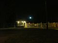
The gate that thwarted our valiant efforts

Achievements
Mitchell and Mason earned the No trespassing consolation prize
|