Difference between revisions of "2015-09-27 49 8"
imported>DODO (→Tracklog) |
imported>FippeBot m (Location) |
||
| (3 intermediate revisions by one other user not shown) | |||
| Line 33: | Line 33: | ||
== Expedition == | == Expedition == | ||
<!-- how it all turned out. your narrative goes here. --> | <!-- how it all turned out. your narrative goes here. --> | ||
| − | Pretty much as planned. We started in Speyer, picked up some mushrooms that stood next to the track, and after one and a half hour we came next to the hash. As expected it was in a private garden and the next we came was | + | Pretty much as planned. We started in Speyer, picked up some mushrooms that stood next to the track, and after one and a half hour we came next to the hash. As expected it was in a private garden and the next we came was 19 m. All we could see from it was a metal sheet on the other side of a stream. There had been a bridge some 20 m backwards, but as I knew that I wouldn't get closer to the cashpoint from the other side and the lady isn't to much in hashing anyway, I resigned on that. After a short stop we continued our way to Edenkoben. There was a wine festival where we had some cake and some coffee in a church. After that we rode home again and had a real nice trip on a sunny sunday. |
== Tracklog == | == Tracklog == | ||
| Line 44: | Line 44: | ||
--> | --> | ||
<gallery perrow="5"> | <gallery perrow="5"> | ||
| + | Image:2015-09-27_49_8-1.jpg|view to the hash (or in hash-direction) | ||
| + | Image:2015-09-27_49_8-3.jpg|still 19 m away | ||
| + | Image:2015-09-27_49_8-2.jpg|the lady and the hasher | ||
| + | Image:2015-09-27_49_8-4.jpg|the bikes | ||
| + | Image:2015-09-27_49_8-5.jpg|coffee and cake in the church | ||
</gallery> | </gallery> | ||
| Line 50: | Line 55: | ||
<!-- Add any achievement ribbons you earned below, or remove this section --> | <!-- Add any achievement ribbons you earned below, or remove this section --> | ||
| − | + | {{No trespassing | |
| − | + | | latitude = 49 | |
| − | + | | longitude = 8 | |
| + | | date = 2015-09-27 | ||
| + | | name = DODO | ||
| + | | distance = 19m | ||
| − | + | }} | |
| − | |||
| − | |||
| − | |||
| − | |||
| − | |||
| − | |||
[[Category:Expeditions]] | [[Category:Expeditions]] | ||
| − | |||
| − | |||
| − | |||
| − | |||
| − | |||
| − | |||
| − | |||
| − | |||
| − | |||
| − | |||
| − | |||
[[Category:Coordinates not reached]] | [[Category:Coordinates not reached]] | ||
| − | |||
| − | |||
| − | |||
| − | |||
| − | |||
[[Category:Not reached - No public access]] | [[Category:Not reached - No public access]] | ||
| − | + | {{location|DE|RP|NW}} | |
| − | |||
| − | |||
| − | |||
| − | |||
| − | |||
| − | |||
| − | |||
Latest revision as of 05:16, 15 August 2019
| Sun 27 Sep 2015 in 49,8: 49.3563794, 8.1665555 geohashing.info google osm bing/os kml crox |
Location
In a private garden in Neustadt an der Weinstraße.
Participants
DODO and the lady
Plans
As the lady and I wanted to go hiking today, I didn't expect to go to todays hash. But then the lady suggested to go biking to Edenkoben, and so I choose a route from Speyer via Neustadt to Edenkoben and back to Speyer. After that I remembered, that the cashpoint is near Neustadt, and when I looked at it, it was almost next to the chosen route.
Expedition
Pretty much as planned. We started in Speyer, picked up some mushrooms that stood next to the track, and after one and a half hour we came next to the hash. As expected it was in a private garden and the next we came was 19 m. All we could see from it was a metal sheet on the other side of a stream. There had been a bridge some 20 m backwards, but as I knew that I wouldn't get closer to the cashpoint from the other side and the lady isn't to much in hashing anyway, I resigned on that. After a short stop we continued our way to Edenkoben. There was a wine festival where we had some cake and some coffee in a church. After that we rode home again and had a real nice trip on a sunny sunday.
Tracklog
Photos
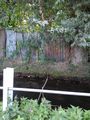
view to the hash (or in hash-direction)
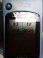
still 19 m away
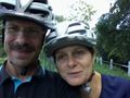
the lady and the hasher
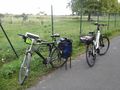
the bikes
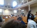
coffee and cake in the church


Achievements
DODO earned the No trespassing consolation prize
|