Difference between revisions of "2015-10-03 48 8"
imported>FippeBot m (Location) |
m |
||
| Line 36: | Line 36: | ||
[[Category:Expeditions]] | [[Category:Expeditions]] | ||
| + | [[Category:Coordinates not reached]] | ||
[[Category:Not reached - No public access]] | [[Category:Not reached - No public access]] | ||
{{location|DE|BW|KA|city=true}} | {{location|DE|BW|KA|city=true}} | ||
Latest revision as of 10:19, 12 September 2021

| Sat 3 Oct 2015 in 48,8: 48.9958764, 8.4999272 geohashing.info google osm bing/os kml crox |
Location
East of Karlsruhe and Durlach in Grötzingen. East of the "Turmberg", a hill in Durlach with a beautiful view.
Participants
Plans
It is not far and in a nice location near the Turmberg. Wheather should also be sunny. If somebody wants to join and doesn't know what to do afterwards, in there is an Oktoberfest in the HaDiKo, a dormatory where I just moved in. Maybe I might talk some new neighbours into joining me.
Expedition
Went by bycicle in the evening, after 7 pm. Climbed the Turmberg, which was an ascent of about 140 m with an inclination of up to 13%. The view from up there was really beautiful, I like going there. Couldn't reach the exact geohash location, as a gate and a fence seperated me from it. I got 20 m close. I guessed that this might happen. If it were a faraway geohash, it would have been a pity, but it was a nice bike ride of 10 km (there and back another 10 km), so it was totally worth it.
Photos
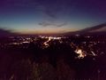
View on Karlsruhe by night from the Turmberg.