Difference between revisions of "2015-10-09 52 5"
imported>Xnyhps (Created page with "{{subst:Expedition |lat = 52 |lon = 5 |date = 2015-10-09 }}") |
imported>FippeBot m (Location) |
||
| (8 intermediate revisions by 2 users not shown) | |||
| Line 19: | Line 19: | ||
== Location == | == Location == | ||
| − | + | Hindersteyn, near Langbroek, Utrecht. | |
== Participants == | == Participants == | ||
| − | + | [[User:Xnyhps|xnyhps]] ([[User talk:Xnyhps|talk]]) | |
| − | |||
== Plans == | == Plans == | ||
| − | + | ||
| + | === xnyhps === | ||
| + | While I had been following geohashing for a while, none of them showed up close enough for me to be able to get there. A couple of days ago, I promised myself "if one comes within 15 km, I'll go there". And then this one showed up... at 16 km. Well, close enough. As long as it wasn't raining, I'd go there. | ||
| + | |||
== Expedition == | == Expedition == | ||
| − | + | ||
| + | === xnyhps === | ||
| + | No rain was predicted, so I left around 10 AM. There was some fog, but it had mostly cleared. In Driebergen, I made a few stops to capture some Ingress portals. As I was leaving Driebergen, the fog was suddenly back. I had to drive for 5 km along a narrow road with cars going 60 km/h and low visibility, this was not a very pleasant. | ||
| + | |||
| + | As I approached the hashpoint, I knew from OpenStreetMap there were two paths leading there. However, OSM had been a bit unclear about which were accessible by bike. Some barriers didn't make it very clear to which path they applied. The first path (Weerdensteijnselaan) didn't forbid cyclists, so I went ahead. It was a rather bumpy ride and at the end I noticed it had shaken loose a part of my bike, but I could continue without it and try to fix it back home. | ||
| + | |||
| + | Now I had to enter a different reserve and the sign was different. It was pretty unclear about whether bikes were allowed, so just to be safe I locked up my bike and continued on foot. It was a pretty nice terrain, some orchards and pastures mixed with forest. I sat down for a bit to drink some tea. Then I tried to get as close to the hashpoint as I could, but it turned out to be a pasture with a fence around it. 160 m was the best I could do, so I left. When I drove back, all the fog was gone and it was sunny and warm. | ||
== Tracklog == | == Tracklog == | ||
| Line 39: | Line 47: | ||
--> | --> | ||
<gallery perrow="5"> | <gallery perrow="5"> | ||
| + | Image:2015-10-09 52 5 Fog.jpeg | Suddenly, fog | ||
| + | Image:2015-10-09 52 5 The sign.jpeg | The sign | ||
| + | Image:2015-10-09 52 5 Orchard.jpeg | Resting in the orchard | ||
| + | Image:2015-10-09 52 5 The hashpoint.jpeg | The hashpoint is somewhere out there | ||
| + | Image:2015-10-09 52 5 Proof.png | Proof | ||
</gallery> | </gallery> | ||
| Line 44: | Line 57: | ||
{{#vardefine:ribbonwidth|800px}} | {{#vardefine:ribbonwidth|800px}} | ||
<!-- Add any achievement ribbons you earned below, or remove this section --> | <!-- Add any achievement ribbons you earned below, or remove this section --> | ||
| + | |||
| + | {{No trespassing | ||
| + | | latitude = 52 | ||
| + | | longitude = 5 | ||
| + | | date = 2015-10-09 | ||
| + | | name = xnyhps | ||
| + | | distance = 160 m | ||
| + | | image = 2015-10-09 52 5 The sign.jpeg | ||
| + | }} | ||
<!-- =============== USEFUL CATEGORIES FOLLOW ================ | <!-- =============== USEFUL CATEGORIES FOLLOW ================ | ||
| − | Delete the next line ONLY if you have chosen the appropriate categories below. If you are unsure, don't worry. People will read your report and help you with the classification. | + | Delete the next line ONLY if you have chosen the appropriate categories below. If you are unsure, don't worry. People will read your report and help you with the classification. |
| − | [[Category:New report]] | + | [[Category:New report]] --> |
<!-- Potential categories. Please include all the ones appropriate to your expedition --> | <!-- Potential categories. Please include all the ones appropriate to your expedition --> | ||
| Line 55: | Line 77: | ||
<!-- If all those plans are never acted upon, change [[Category:Expedition planning]] to [[Category:Not reached - Did not attempt]]. --> | <!-- If all those plans are never acted upon, change [[Category:Expedition planning]] to [[Category:Not reached - Did not attempt]]. --> | ||
| − | |||
| − | |||
[[Category:Expeditions]] | [[Category:Expeditions]] | ||
| − | |||
[[Category:Expeditions with photos]] | [[Category:Expeditions with photos]] | ||
| − | |||
| − | |||
| − | |||
<!-- if you reached your coords: | <!-- if you reached your coords: | ||
| Line 68: | Line 84: | ||
| − | --> | + | --> |
| + | |||
[[Category:Coordinates not reached]] | [[Category:Coordinates not reached]] | ||
| − | |||
| − | |||
| − | |||
| − | |||
| − | |||
[[Category:Not reached - No public access]] | [[Category:Not reached - No public access]] | ||
| − | + | {{location|NL|UT}} | |
| − | |||
| − | |||
| − | |||
| − | |||
| − | |||
| − | |||
| − | |||
Latest revision as of 05:24, 15 August 2019
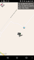
| Fri 9 Oct 2015 in 52,5: 52.0049153, 5.3013955 geohashing.info google osm bing/os kml crox |
Location
Hindersteyn, near Langbroek, Utrecht.
Participants
Plans
xnyhps
While I had been following geohashing for a while, none of them showed up close enough for me to be able to get there. A couple of days ago, I promised myself "if one comes within 15 km, I'll go there". And then this one showed up... at 16 km. Well, close enough. As long as it wasn't raining, I'd go there.
Expedition
xnyhps
No rain was predicted, so I left around 10 AM. There was some fog, but it had mostly cleared. In Driebergen, I made a few stops to capture some Ingress portals. As I was leaving Driebergen, the fog was suddenly back. I had to drive for 5 km along a narrow road with cars going 60 km/h and low visibility, this was not a very pleasant.
As I approached the hashpoint, I knew from OpenStreetMap there were two paths leading there. However, OSM had been a bit unclear about which were accessible by bike. Some barriers didn't make it very clear to which path they applied. The first path (Weerdensteijnselaan) didn't forbid cyclists, so I went ahead. It was a rather bumpy ride and at the end I noticed it had shaken loose a part of my bike, but I could continue without it and try to fix it back home.
Now I had to enter a different reserve and the sign was different. It was pretty unclear about whether bikes were allowed, so just to be safe I locked up my bike and continued on foot. It was a pretty nice terrain, some orchards and pastures mixed with forest. I sat down for a bit to drink some tea. Then I tried to get as close to the hashpoint as I could, but it turned out to be a pasture with a fence around it. 160 m was the best I could do, so I left. When I drove back, all the fog was gone and it was sunny and warm.
Tracklog
Photos
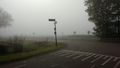
Suddenly, fog
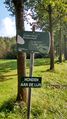
The sign
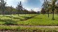
Resting in the orchard
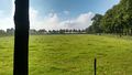
The hashpoint is somewhere out there
Proof


Achievements
xnyhps earned the No trespassing consolation prize
|