Difference between revisions of "2015-10-18 53 -2"
From Geohashing
imported>Angel ([retro picture]A panorama from the hash [http://www.openstreetmap.org/?lat=54.04386710&lon=-2.79219070&zoom=16&layers=B000FTF @54.0439,-2.7922]) |
imported>Angel ([retro picture]Actual hashpoint is between the gate and the railway lines, as close as I can tell. [http://www.openstreetmap.org/?lat=54.04385340&lon=-2.79224200&zoom=16&layers=B000FTF @54.0439,-2.7922]) |
||
| Line 43: | Line 43: | ||
Image:2015-10-18_53_-2_Angel_1447443848382.jpg|A panorama from the hash [http://www.openstreetmap.org/?lat=54.04386710&lon=-2.79219070&zoom=16&layers=B000FTF @54.0439,-2.7922] | Image:2015-10-18_53_-2_Angel_1447443848382.jpg|A panorama from the hash [http://www.openstreetmap.org/?lat=54.04386710&lon=-2.79219070&zoom=16&layers=B000FTF @54.0439,-2.7922] | ||
| + | |||
| + | Image:2015-10-18_53_-2_Angel_1447443923839.jpg|Actual hashpoint is between the gate and the railway lines, as close as I can tell. [http://www.openstreetmap.org/?lat=54.04385340&lon=-2.79224200&zoom=16&layers=B000FTF @54.0439,-2.7922] | ||
</gallery> | </gallery> | ||
Revision as of 19:43, 13 November 2015
| Sun 18 Oct 2015 in 53,-2: 53.5875861, -2.7583232 geohashing.info google osm bing/os kml crox |
Location
Participants
Plans
Expedition
Tracklog
Photos
Made it... only just realised I didn't get around to posting on the day.
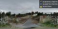
A panorama from the hash @54.0439,-2.7922
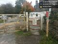
Actual hashpoint is between the gate and the railway lines, as close as I can tell. @54.0439,-2.7922


Achievements