Difference between revisions of "2015-10-26 51 9"
From Geohashing
imported>GeorgDerReisende (new report) |
imported>FippeBot m (Location) |
||
| (One intermediate revision by one other user not shown) | |||
| Line 1: | Line 1: | ||
| − | |||
| − | |||
| − | |||
| − | |||
| − | |||
| − | |||
| − | |||
| − | |||
| − | |||
| − | |||
{{meetup graticule | {{meetup graticule | ||
| lat=51 | | lat=51 | ||
| Line 19: | Line 9: | ||
== Location == | == Location == | ||
| − | + | ||
| + | The hash lay at the side of a shed at the place Engelbrechtzerfeld. | ||
== Participants == | == Participants == | ||
| − | + | ||
| − | + | [[User:GeorgDerReisende|GeorgDerReisende]] | |
== Plans == | == Plans == | ||
| − | + | ||
| + | Hitchhiking and walking. | ||
== Expedition == | == Expedition == | ||
| − | |||
| − | + | I hitchhiked from Kassel to Viesebeck with two cars. Walked to the place of hash. And found it. 22 meters on private property. I wanted to ask somebody for permission, but it was nobody there. So I couldn't go there. | |
| − | |||
== Photos == | == Photos == | ||
| Line 39: | Line 29: | ||
--> | --> | ||
<gallery perrow="5"> | <gallery perrow="5"> | ||
| + | Image:2015-10-26 51 9 GeorgDerReisende 6686.jpg | 22 meters too far | ||
| + | Image:2015-10-26 51 9 GeorgDerReisende 6698.jpg | I had been here at [[2014-09-10 51 9]]. | ||
</gallery> | </gallery> | ||
| Line 45: | Line 37: | ||
<!-- Add any achievement ribbons you earned below, or remove this section --> | <!-- Add any achievement ribbons you earned below, or remove this section --> | ||
| − | + | {{No trespassing | latitude = 51 | longitude = 9 | date = 2015-10-26 | distance = 22 meters }} | |
| − | |||
| − | |||
| − | + | [[Category:Expeditions]] | |
| − | |||
| − | [[Category: | ||
| − | |||
| − | |||
| − | |||
| − | |||
| − | |||
| − | |||
[[Category:Expeditions with photos]] | [[Category:Expeditions with photos]] | ||
| − | |||
| − | |||
| − | |||
| − | |||
| − | |||
| − | |||
| + | [[Category:Coordinates not reached]] | ||
| − | |||
| − | |||
| − | |||
| − | |||
| − | |||
| − | |||
| − | |||
[[Category:Not reached - No public access]] | [[Category:Not reached - No public access]] | ||
| − | + | {{location|DE|HE|KS}} | |
| − | |||
| − | |||
| − | |||
| − | |||
| − | |||
| − | |||
| − | |||
Latest revision as of 05:36, 15 August 2019
| Mon 26 Oct 2015 in 51,9: 51.3502114, 9.1396364 geohashing.info google osm bing/os kml crox |
Location
The hash lay at the side of a shed at the place Engelbrechtzerfeld.
Participants
Plans
Hitchhiking and walking.
Expedition
I hitchhiked from Kassel to Viesebeck with two cars. Walked to the place of hash. And found it. 22 meters on private property. I wanted to ask somebody for permission, but it was nobody there. So I couldn't go there.
Photos
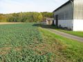
22 meters too far
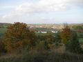
I had been here at 2014-09-10 51 9.


Achievements
This user earned the No trespassing consolation prize
|