Difference between revisions of "2015-11-14 -35 149"
imported>1PE (Created page with "{{subst:Expedition |lat = -35 |lon = 149 |date = 2015-11-14}}") |
imported>FippeBot m (Location) |
||
| (3 intermediate revisions by 2 users not shown) | |||
| Line 19: | Line 19: | ||
== Location == | == Location == | ||
| − | + | A farmer's field beside the Molonglo River corridor. | |
== Participants == | == Participants == | ||
| − | + | ===[[User:1PE|1PE]]=== | |
| − | |||
== Plans == | == Plans == | ||
| − | + | ===[[User:1PE|1PE]]=== | |
| + | It was apparent that this would not be possible except by proxy while looking from a nearby road. I worked out how to line up several farm dams to indicate where the hash was, to take a picture in the correct direction. | ||
== Expedition == | == Expedition == | ||
| − | + | ===[[User:1PE|1PE]]=== | |
| + | I drove along the road to the north-east of the hash, found the nearest dam, lined up the next dam, and took several pictures. The hash was just north-east of the road that allows servicing of Canberra's main water supply pipe, that runs along the Molonglo River above ground at this point. These winding gravel roads are sometimes used for car rallies. They are locked-roads within the farm this point (hence unable to be accessed); other roads used are in government forests, where the public can go, normally. | ||
| + | |||
| + | A kite (raptor bird) was flying nearby, including several times stopping stationary while looking for prey. There is a picture showing this, but the bird may not be visible. | ||
== Tracklog == | == Tracklog == | ||
| Line 39: | Line 42: | ||
--> | --> | ||
<gallery perrow="5"> | <gallery perrow="5"> | ||
| + | Image:20151114_-35_149_view.jpg|The hash is beyond the small tree to the right of the farm dam. Note the water pipe (white streak) beyond the hash. | ||
| + | Image:20151114_-35_149_kite-raptor.jpg|Raptor, hovering, barely visible to the top-right of the tree. | ||
</gallery> | </gallery> | ||
| Line 47: | Line 52: | ||
<!-- =============== USEFUL CATEGORIES FOLLOW ================ | <!-- =============== USEFUL CATEGORIES FOLLOW ================ | ||
Delete the next line ONLY if you have chosen the appropriate categories below. If you are unsure, don't worry. People will read your report and help you with the classification. --> | Delete the next line ONLY if you have chosen the appropriate categories below. If you are unsure, don't worry. People will read your report and help you with the classification. --> | ||
| − | |||
| − | |||
| − | |||
| − | |||
| − | |||
| − | |||
| − | |||
| − | |||
| − | |||
[[Category:Expeditions]] | [[Category:Expeditions]] | ||
| − | |||
[[Category:Expeditions with photos]] | [[Category:Expeditions with photos]] | ||
| − | |||
| − | |||
| − | |||
| − | |||
| − | |||
| − | |||
| − | |||
| − | |||
| − | |||
[[Category:Coordinates not reached]] | [[Category:Coordinates not reached]] | ||
| − | |||
| − | |||
| − | |||
| − | |||
| − | |||
[[Category:Not reached - No public access]] | [[Category:Not reached - No public access]] | ||
| − | + | {{location|AU|ACT}} | |
| − | |||
| − | |||
| − | |||
| − | |||
| − | |||
| − | |||
| − | |||
Latest revision as of 05:49, 15 August 2019
| Sat 14 Nov 2015 in -35,149: -35.2620441, 149.0104483 geohashing.info google osm bing/os kml crox |
Location
A farmer's field beside the Molonglo River corridor.
Participants
1PE
Plans
1PE
It was apparent that this would not be possible except by proxy while looking from a nearby road. I worked out how to line up several farm dams to indicate where the hash was, to take a picture in the correct direction.
Expedition
1PE
I drove along the road to the north-east of the hash, found the nearest dam, lined up the next dam, and took several pictures. The hash was just north-east of the road that allows servicing of Canberra's main water supply pipe, that runs along the Molonglo River above ground at this point. These winding gravel roads are sometimes used for car rallies. They are locked-roads within the farm this point (hence unable to be accessed); other roads used are in government forests, where the public can go, normally.
A kite (raptor bird) was flying nearby, including several times stopping stationary while looking for prey. There is a picture showing this, but the bird may not be visible.
Tracklog
Photos
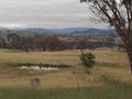
The hash is beyond the small tree to the right of the farm dam. Note the water pipe (white streak) beyond the hash.
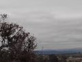
Raptor, hovering, barely visible to the top-right of the tree.

