Difference between revisions of "2015-12-01 52 5"
From Geohashing
imported>Xnyhps |
m |
||
| (4 intermediate revisions by 2 users not shown) | |||
| Line 19: | Line 19: | ||
== Location == | == Location == | ||
| − | Utrecht, The Netherlands. | + | Near a greenhouse next to Utrecht, The Netherlands. |
== Participants == | == Participants == | ||
| − | + | [[User:Xnyhps|xnyhps]] ([[User talk:Xnyhps|talk]]) | |
| − | |||
== Plans == | == Plans == | ||
| Line 32: | Line 31: | ||
== Expedition == | == Expedition == | ||
| − | + | ||
| + | === xnyhps === | ||
| + | |||
| + | As expected, the hash was unreachable, I didn't feel like trespassing through a lot of mud (it was raining a bit). Got up to 171m, which was as close as the public road could get me. | ||
== Tracklog == | == Tracklog == | ||
| Line 42: | Line 44: | ||
--> | --> | ||
<gallery perrow="5"> | <gallery perrow="5"> | ||
| + | Image:Geohash 2015 12 01 52 5.jpg | About 170m further in this direction. | ||
</gallery> | </gallery> | ||
| Line 48: | Line 51: | ||
<!-- Add any achievement ribbons you earned below, or remove this section --> | <!-- Add any achievement ribbons you earned below, or remove this section --> | ||
| − | |||
| − | |||
| − | |||
| − | |||
| − | |||
| − | |||
| − | |||
| − | |||
| − | |||
| − | |||
| − | |||
| − | |||
[[Category:Expeditions]] | [[Category:Expeditions]] | ||
| − | |||
| − | |||
| − | |||
| − | |||
| − | |||
| − | |||
| − | |||
| − | |||
| − | |||
| − | |||
| − | |||
[[Category:Coordinates not reached]] | [[Category:Coordinates not reached]] | ||
| − | |||
| − | |||
| − | |||
| − | |||
| − | |||
[[Category:Not reached - No public access]] | [[Category:Not reached - No public access]] | ||
| − | + | {{location|NL|UT}} | |
| − | |||
| − | |||
| − | |||
| − | |||
| − | |||
| − | |||
| − | |||
Latest revision as of 15:36, 22 September 2021
| Tue 1 Dec 2015 in 52,5: 52.0716955, 5.1425712 geohashing.info google osm bing/os kml crox |
Location
Near a greenhouse next to Utrecht, The Netherlands.
Participants
Plans
xnyhps
If it's not raining (too hard), I'll try to get to the hashpoint. It doesn't look publicly accessible, but it's close enough to try.
Expedition
xnyhps
As expected, the hash was unreachable, I didn't feel like trespassing through a lot of mud (it was raining a bit). Got up to 171m, which was as close as the public road could get me.
Tracklog
Photos
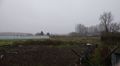
About 170m further in this direction.
