Difference between revisions of "2015-12-24 52 4"
imported>Palmpje |
imported>FippeBot m (Location) |
||
| (2 intermediate revisions by one other user not shown) | |||
| Line 36: | Line 36: | ||
| − | <!-- =============== USEFUL CATEGORIES FOLLOW ================ | + | <!-- =============== USEFUL CATEGORIES FOLLOW ================ --> |
[[Category:Expeditions]] | [[Category:Expeditions]] | ||
[[Category:Expeditions with photos]] | [[Category:Expeditions with photos]] | ||
[[Category:Coordinates not reached]] | [[Category:Coordinates not reached]] | ||
[[Category:Not reached - No public access]] | [[Category:Not reached - No public access]] | ||
| + | {{location|NL|ZH}} | ||
Latest revision as of 06:14, 15 August 2019

| Thu 24 Dec 2015 in 52,4: 52.1584969, 4.3788291 geohashing.info google osm bing/os kml crox |
Location
In the dunes near Wassenaar. Near a bicycle path.
Participants
- Palmpje went for a walk (after driving there)
Plans
Drive to a parking spot about 800m away and see which path comes close.
Expedition
All went well, until I reached the area where the water company has it's infiltration area. This area is off limits as water from the rivers is filtered here in the dunes (they just pump it in and let it soak through, then pump it out of the water pockets under the dunes again). Although tere were very convenient step-overs into the area, everything was clearly marked as no access! While walking along the fence I discovered that I had made a typo in converting to the mm.mmm format I normally use. When I put in the decimal representation I could get to 79 meters but that was too far away for any chanche of success. Well, I did have a nice walk.
Photos
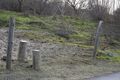
Just step over?
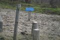
Not allowed...
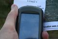
So close, yet so far


Achievements
Palmpje earned the No trespassing consolation prize
|