Difference between revisions of "2016-01-01 49 8"
From Geohashing
imported>Q-Owl m (→Achievements) |
imported>Q-Owl |
||
| Line 1: | Line 1: | ||
| − | + | [[Image:2016-01-01 49 8 hp.jpg|thumb|left|Tree at the Hashpoint]] | |
| − | |||
| − | |||
| − | [[Image: | ||
| − | |||
| − | |||
| − | |||
| − | |||
| − | |||
| − | |||
{{meetup graticule | {{meetup graticule | ||
| lat=49 | | lat=49 | ||
| Line 19: | Line 10: | ||
== Location == | == Location == | ||
| − | + | ||
| + | In a wood near [[wikipedia:Seeheim-Jugenheim|Seeheim]] | ||
== Participants == | == Participants == | ||
| − | + | ||
| − | |||
*[[User:Yakamoz|Yakamoz]] | *[[User:Yakamoz|Yakamoz]] | ||
*[[User:Q-Owl|Q-Owl]] | *[[User:Q-Owl|Q-Owl]] | ||
| Line 32: | Line 23: | ||
== Expedition == | == Expedition == | ||
| − | + | ||
| + | ... ... ... | ||
== Tracklog == | == Tracklog == | ||
| Line 68: | Line 60: | ||
<!-- =============== USEFUL CATEGORIES FOLLOW ================ | <!-- =============== USEFUL CATEGORIES FOLLOW ================ | ||
| − | |||
| − | |||
| − | |||
| − | |||
| − | |||
| − | |||
| − | |||
| − | |||
| − | |||
| − | |||
| − | |||
| − | |||
[[Category:Expeditions with photos]] | [[Category:Expeditions with photos]] | ||
| − | |||
| − | |||
| − | |||
| − | |||
| − | |||
[[Category:Coordinates reached]] | [[Category:Coordinates reached]] | ||
| − | + | <!-- or if you failed :( | |
| − | |||
[[Category:Coordinates not reached]] | [[Category:Coordinates not reached]] | ||
-- and a reason -- | -- and a reason -- | ||
Revision as of 16:02, 1 January 2016

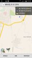
| Fri 1 Jan 2016 in 49,8: 49.7836848, 8.6439332 geohashing.info google osm bing/os kml crox |
Location
In a wood near Seeheim
Participants
Plans
Expedition
... ... ...
Tracklog
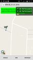
Photos
we only had 2,6 km to go
very close to the point


Achievements
Q-Owl, Q-Owla and Yakamoz earned the Land geohash achievement
|
Q-Owl, Q-Owla and Yakamoz earned the Avoid Each Other Achievement
|