Difference between revisions of "2016-01-02 53 -1"
From Geohashing
imported>Danheller (→Location) |
m |
||
| (5 intermediate revisions by 5 users not shown) | |||
| Line 25: | Line 25: | ||
<!-- who attended: If you link to your wiki user name in this section, your expedition will be picked up by the various statistics generated for geohashing. You may use three tildes ~ as a shortcut to automatically insert the user signature of the account you are editing with. | <!-- who attended: If you link to your wiki user name in this section, your expedition will be picked up by the various statistics generated for geohashing. You may use three tildes ~ as a shortcut to automatically insert the user signature of the account you are editing with. | ||
--> | --> | ||
| + | *[[User:Danheller|Danheller]] | ||
== Plans == | == Plans == | ||
| Line 40: | Line 41: | ||
--> | --> | ||
<gallery perrow="5"> | <gallery perrow="5"> | ||
| + | |||
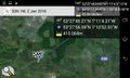
| + | Image:2016-01-02_53_-1_Danheller _1451808816958.jpg|Got it! [http://www.openstreetmap.org/?lat=53.35497630&lon=-1.47189390&zoom=16&layers=B000FTF @53.3550,-1.4719] | ||
</gallery> | </gallery> | ||
| Line 48: | Line 51: | ||
<!-- =============== USEFUL CATEGORIES FOLLOW ================ | <!-- =============== USEFUL CATEGORIES FOLLOW ================ | ||
Delete the next line ONLY if you have chosen the appropriate categories below. If you are unsure, don't worry. People will read your report and help you with the classification. --> | Delete the next line ONLY if you have chosen the appropriate categories below. If you are unsure, don't worry. People will read your report and help you with the classification. --> | ||
| − | |||
| − | |||
| − | |||
| − | |||
| − | |||
| − | |||
| − | |||
| − | |||
| − | |||
[[Category:Expeditions]] | [[Category:Expeditions]] | ||
| − | |||
[[Category:Expeditions with photos]] | [[Category:Expeditions with photos]] | ||
| − | |||
| − | |||
| − | |||
| − | |||
| − | |||
| − | |||
| − | |||
| − | |||
| − | |||
[[Category:Coordinates not reached]] | [[Category:Coordinates not reached]] | ||
| − | + | [[Category:Not reached - Unknown]] | |
| − | + | {{location|GB|ENG|DNC}} | |
| − | |||
| − | |||
| − | |||
| − | [[Category:Not reached - | ||
| − | |||
| − | |||
| − | |||
| − | |||
| − | |||
| − | |||
| − | |||
| − | |||
Latest revision as of 11:53, 27 March 2022
| Sat 2 Jan 2016 in 53,-1: 53.4625582, -1.1845310 geohashing.info google osm bing/os kml crox |
Location
Off the M18, between Junctions 2 and 1. About 200m South of the carriageway.
Participants
Plans
Expedition
Tracklog
Photos
Got it! @53.3550,-1.4719
