Difference between revisions of "2016-02-15 43 -78"
imported>Pedalpusher (→Expedition) |
imported>FippeBot m (Location) |
||
| (One intermediate revision by one other user not shown) | |||
| Line 25: | Line 25: | ||
== Photos == | == Photos == | ||
<gallery perrow="5"> | <gallery perrow="5"> | ||
| − | Image: | + | Image: 2015-02-15 fingerLakesTrail.jpg | We parked close to the trail sign. |
| − | Image: | + | Image: 2015-02-15 byRoad.jpg | Walking in toward the hash. |
| − | Image: | + | Image: 2015-02-15 trail.jpg | The dogs had a blast on our hike. |
| − | Image: | + | Image: 2015-02-15 gps.jpg | As close as I could get... |
| − | Image: | + | Image: 2015-02-15 posted.jpg | ...because it's posted. |
| − | |||
| − | |||
| − | |||
</gallery> | </gallery> | ||
| Line 44: | Line 41: | ||
}} | }} | ||
| − | |||
[[Category:Expeditions]] | [[Category:Expeditions]] | ||
[[Category:Coordinates not reached]] | [[Category:Coordinates not reached]] | ||
[[Category:Not reached - No public access]] | [[Category:Not reached - No public access]] | ||
| − | + | [[Category:Expeditions with photos]] | |
[[Category:Expeditions with dogs]] | [[Category:Expeditions with dogs]] | ||
| + | {{location|US|NY|GE}} | ||
Latest revision as of 06:42, 15 August 2019
| Mon 15 Feb 2016 in 43,-78: 43.0055425, -78.4584458 geohashing.info google osm bing/os kml crox |
Location
In a field by Murder Creek; Near Akron, NY
Participants
- Pedalpusher
- Simon the dog
- Myka the dog
Interesting local history
Before I get into the report, a Note on Murder Creek. There was another hash last year that was close to this creek as well, but clearly on private property so I didn't go to that one. I had mentioned it on IRC though and I believe it was Crox that was interested in knowing more about it. I looked around online and found a Legend about it that involved Native Americans and early settlers to the area.
Expedition
I really wasn't planning on going to this geohash, but on Monday morning, I rechecked the hash. In looking at the street-view previously, I saw some kinds of signs on the posts/gate of the path and I wasn't sure if they were posted signs. I really didn't want to drive an hour with the dogs only to be turned away before we even got out of the car. On my morning check, however, a green Hiking sign caught my eye. That meant I would at least have access to the trail under the wires and I was happy to go.
Getting there, I saw the hiking sign indicated it was the Fingerlakes Trail (the lakes of that group are in Central NY) which I didn't realize came all the way out to Western NY. Walking to the trail, I could see in the winter it's used as a Snow-mobile trail, but fortunately, the snow was shallow enough that no one was riding.
Walking down the trail, I could see the multitude of Posted signs all along both sides, and my only hope was that the hash was on a piece of property that wasn't posted. While there were some sections that weren't posted, when I got as close as I could to the hash on the trail, there were still signs by that section. I got a few pictures and continued along the trail to the next road crossing for an extended hike.
I got to see a few hawks(too far away to identify), a deer that crossed the trail well ahead of us and on the way back to the car, a lone hiker going the other way. We just said hi and he greeted the dogs before we all continued on our way. On the way home, I also saw a huge flock of wild turkeys in a field.
It was a nice hike despite not being able to make it to the hash and I know the dogs really enjoyed themselves.
Photos
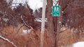
We parked close to the trail sign.
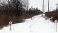
Walking in toward the hash.

The dogs had a blast on our hike.

As close as I could get...
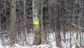
...because it's posted.


Ribbons
Pedalpusher earned the No trespassing consolation prize
|