2016-04-16 -37 145

| Sat 16 Apr 2016 in -37,145: -37.6422736, 145.3089662 geohashing.info google osm bing/os kml crox |
Location
Participants
~~
Plans
Shoot on out via Warrandyte, through Christmas Hills and to the hashpoint. Looks to be on a driveway to a private property.
Expedition
Another Saturday, another geohash. This looked unachievable from the get go based on the satellite pics - no easy clear access and on private property.
I rode out via Warrandyte, great morning for it. Birds everywhere and kangaroos boxing in the dawn. Beautiful country.
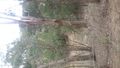
It was pretty undulating and the country around the hash point no different. I didn't scope the final road to the destination properly and of course it turned out to be gravel, fortunately not more than about a km. Mainly bush with some clearing, at one point a massive barn stocked with hay.
The road splits around the hash point, I went the main road till parallel with the point. On the way back I looked at going up the side road; it was really steep and again was on a road bike so thought nah. In hindsight it would've been worthwhile taking a peek given there is a property for sale which may have been the one with the hash point.
Got to 100m away, it's off a gravel road called One Tree Hill Road out the back of Sugarloaf Reservoir. -- Kozz (talk) 09:03, 16 April 2016 (GMT+10:00)
Tracklog
Photos
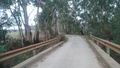
Bridge in
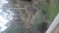
Dry Creek
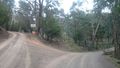
Fork in road
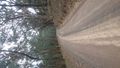
Road in
Towards hashpoint
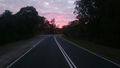
Sunrise
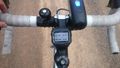
Garmin


Achievements
Kozz earned the Bicycle geohash achievement
|