Difference between revisions of "2016-04-23 48 9"
imported>Drei aus Korb (→Location) |
m |
||
| (13 intermediate revisions by 3 users not shown) | |||
| Line 22: | Line 22: | ||
== Participants == | == Participants == | ||
| − | + | Holger / [[User:Drei aus Korb|Drei aus Korb]] | |
| − | |||
== Plans == | == Plans == | ||
| − | + | No plan, just go! | |
== Expedition == | == Expedition == | ||
| − | + | Da die Koordinaten für heute lediglich einen mehr oder weniger unwesentlichen Umweg zwischen Heimat und Arbeitsstätte bedeuteten habe ich mich trotz Zeitmangel und Regenwetter darauf eingelassen. Gut, der tatsächliche Umweg war dann doch nicht ganz unerheblich, dem Ziel konnte ich mich aber auf unter 300 m mit dem Kfz nähern. Leider stellte sich heraus dass zwar ein Feldweg hinter einer Gärtnerei direkt zum angepeilten Ort führt, ich aber einen frisch bestellten Acker hätte betreten müssen. Nicht nur dass ich hier wie auf dem Präsentierteller gestanden hätte, auch aus dem Respekt vor dem Werk des Landmanns kam es für mich nicht in Frage denselben zu betreten. | |
| + | |||
| + | Zwar konnte ich mich so nur auf 26,011576m nähern, doch da kamen mir die wohl durch den stark bedeckten Himmel springenden Koordinaten zu Hilfe: der Geohash Droid meldete "You're there!". Auf einmal war ich 3m näher. Ob das wohl gilt? ;-) | ||
| + | |||
| − | + | Short summary in English: | |
| − | + | ||
| + | The coordinates for today led to a field in Bietigheim-Bissingen near Ludwigsburg, Germany. It was a rainy day but I was able to reach the target as close as about 300 Meters by car. Unfortunatly it wasn't possible to get any closer because the farmers just had been tilling the land. | ||
== Photos == | == Photos == | ||
| Line 41: | Line 44: | ||
Image:2016-04-23_48_9_Drei aus Korb _1461393239312.jpg|Bietigheim-Bissingen [http://www.openstreetmap.org/?lat=48.93123640&lon=9.11376470&zoom=16&layers=B000FTF @48.9312,9.1138] | Image:2016-04-23_48_9_Drei aus Korb _1461393239312.jpg|Bietigheim-Bissingen [http://www.openstreetmap.org/?lat=48.93123640&lon=9.11376470&zoom=16&layers=B000FTF @48.9312,9.1138] | ||
| + | Image:Screenshot 2016-04-23-08-32-02.png | Geohash Droid Screenshot | ||
| + | Image:Thisway.JPG | This way! | ||
| + | Image:Nearby.JPG | Nearby | ||
</gallery> | </gallery> | ||
| − | |||
| − | |||
| − | |||
| − | |||
| − | |||
| − | |||
| − | |||
| − | |||
| − | |||
| − | |||
| − | |||
| − | |||
| − | |||
| − | |||
| − | |||
| − | |||
[[Category:Expeditions]] | [[Category:Expeditions]] | ||
| − | |||
[[Category:Expeditions with photos]] | [[Category:Expeditions with photos]] | ||
| − | |||
| − | |||
| − | |||
| − | |||
| − | |||
| − | |||
| − | |||
| − | |||
| − | |||
[[Category:Coordinates not reached]] | [[Category:Coordinates not reached]] | ||
| − | |||
| − | |||
| − | |||
| − | |||
| − | |||
[[Category:Not reached - No public access]] | [[Category:Not reached - No public access]] | ||
| − | + | {{location|DE|BW|LB}} | |
| − | |||
| − | |||
| − | |||
| − | |||
| − | |||
| − | |||
| − | |||
Latest revision as of 06:46, 23 September 2021
| Sat 23 Apr 2016 in 48,9: 48.9312837, 9.1141124 geohashing.info google osm bing/os kml crox |
Location
Bietigheim-Bissingen / Ludwigsburg
Participants
Holger / Drei aus Korb
Plans
No plan, just go!
Expedition
Da die Koordinaten für heute lediglich einen mehr oder weniger unwesentlichen Umweg zwischen Heimat und Arbeitsstätte bedeuteten habe ich mich trotz Zeitmangel und Regenwetter darauf eingelassen. Gut, der tatsächliche Umweg war dann doch nicht ganz unerheblich, dem Ziel konnte ich mich aber auf unter 300 m mit dem Kfz nähern. Leider stellte sich heraus dass zwar ein Feldweg hinter einer Gärtnerei direkt zum angepeilten Ort führt, ich aber einen frisch bestellten Acker hätte betreten müssen. Nicht nur dass ich hier wie auf dem Präsentierteller gestanden hätte, auch aus dem Respekt vor dem Werk des Landmanns kam es für mich nicht in Frage denselben zu betreten.
Zwar konnte ich mich so nur auf 26,011576m nähern, doch da kamen mir die wohl durch den stark bedeckten Himmel springenden Koordinaten zu Hilfe: der Geohash Droid meldete "You're there!". Auf einmal war ich 3m näher. Ob das wohl gilt? ;-)
Short summary in English:
The coordinates for today led to a field in Bietigheim-Bissingen near Ludwigsburg, Germany. It was a rainy day but I was able to reach the target as close as about 300 Meters by car. Unfortunatly it wasn't possible to get any closer because the farmers just had been tilling the land.
Photos
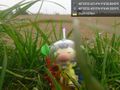
Bietigheim-Bissingen @48.9312,9.1138
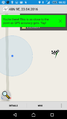
Geohash Droid Screenshot
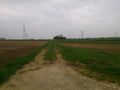
This way!
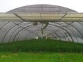
Nearby


