Difference between revisions of "2016-06-02 49 8"
imported>RecentlyChanged |
imported>FippeBot m (Location) |
||
| (One intermediate revision by one other user not shown) | |||
| Line 28: | Line 28: | ||
== Expedition == | == Expedition == | ||
| − | + | I started my expedition around 5pm. | |
| + | I was happy having a reason not to study, so I left earlier then I had planned. | ||
| + | Because I ran out of battery I memorized the way, which was quite easy: follow the Moltkestraße until it ends, turn left and then right again. | ||
| + | Follow the street until I reach the train station. (Or reach the train station after loosing the right track, that should be possible without looking up my position.) | ||
| + | West of the train station I had to take the first possibility to go south. | ||
| + | And at last: Recognize the street to the hash. It had to be on the left hand-side and contain a long straight path. Hopefully not fenced of, even though in an industrial area. | ||
| − | + | To make it short, it worked out as planned and I took out my phone almost exactly at the spot. | |
| − | + | It showed, that it wasn't possible to reach the spot by chance, because it was over a fence. | |
| + | I reached over it as far as I could to feel be at the hash, but in this case I'm not sure. | ||
| + | Measurement on googlemaps is telling me the hash was about 6 feet from the fence. | ||
== Photos == | == Photos == | ||
| Line 38: | Line 45: | ||
--> | --> | ||
<gallery perrow="5"> | <gallery perrow="5"> | ||
| + | File:2016-06-02 18 49 8 proof.png | The best proof I got (regarding the battery life, I'd broken my charger cable, so it had to be enough for the whole friday too!) | ||
| + | File:2016-06-02 49 8 maybe.jpg | I thought maybe he hash was here... | ||
| + | File:2016-06-02 49 8 probably.jpg | but most probably the hash was there. | ||
| + | File:2016-06-02 49 8 myself.jpg | The stupid grin in case I reached it. | ||
| + | File:2016-06-02 49 8 the long path.jpg | The long path with the house to which the fence belongs. | ||
</gallery> | </gallery> | ||
== Achievements == | == Achievements == | ||
{{#vardefine:ribbonwidth|800px}} | {{#vardefine:ribbonwidth|800px}} | ||
| − | + | {{No trespassing | |
| + | |||
| + | | latitude = 49 | ||
| + | | longitude = 8 | ||
| + | | date = 2016-06-02 | ||
| + | | name = [[User:RecentlyChanged|RecentlyChanged]] ([[User_talk:RecentlyChanged|talk]]) | ||
| + | | distance = 2 metres | ||
| + | |||
| + | }} | ||
| − | |||
| − | |||
| − | |||
| − | |||
| − | |||
| − | |||
| − | |||
| − | |||
| − | |||
[[Category:Expeditions]] | [[Category:Expeditions]] | ||
| − | |||
[[Category:Expeditions with photos]] | [[Category:Expeditions with photos]] | ||
| − | |||
[[Category:Expedition without GPS]] | [[Category:Expedition without GPS]] | ||
| − | |||
| − | |||
| − | |||
| − | |||
| − | |||
| − | |||
| − | |||
[[Category:Coordinates not reached]] | [[Category:Coordinates not reached]] | ||
| − | |||
| − | |||
| − | |||
| − | |||
| − | |||
[[Category:Not reached - No public access]] | [[Category:Not reached - No public access]] | ||
| − | + | {{location|DE|RP|GER}} | |
| − | |||
| − | |||
| − | |||
| − | |||
| − | |||
| − | |||
| − | |||
Latest revision as of 00:41, 16 August 2019
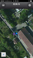
| Thu 2 Jun 2016 in 49,8: 49.0433326, 8.2643468 geohashing.info google osm bing/os kml crox |
Location
On a dead end street, maybe in an industrial area.
Participants
Plans
Drive there from the university with the bike and then home. should take about one and a half hour. Maybe look if I can reach the former hash of 2016-05-26 49 8 because I'm interested in how it would have worked out if the mall would have been open back then.
Expedition
I started my expedition around 5pm. I was happy having a reason not to study, so I left earlier then I had planned. Because I ran out of battery I memorized the way, which was quite easy: follow the Moltkestraße until it ends, turn left and then right again. Follow the street until I reach the train station. (Or reach the train station after loosing the right track, that should be possible without looking up my position.) West of the train station I had to take the first possibility to go south. And at last: Recognize the street to the hash. It had to be on the left hand-side and contain a long straight path. Hopefully not fenced of, even though in an industrial area.
To make it short, it worked out as planned and I took out my phone almost exactly at the spot. It showed, that it wasn't possible to reach the spot by chance, because it was over a fence. I reached over it as far as I could to feel be at the hash, but in this case I'm not sure. Measurement on googlemaps is telling me the hash was about 6 feet from the fence.
Photos
The best proof I got (regarding the battery life, I'd broken my charger cable, so it had to be enough for the whole friday too!)
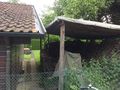
I thought maybe he hash was here...
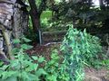
but most probably the hash was there.

The stupid grin in case I reached it.
The long path with the house to which the fence belongs.


Achievements
RecentlyChanged (talk) earned the No trespassing consolation prize
|