Difference between revisions of "2016-06-16 44 -111"
From Geohashing
imported>Bravissimo594 (Created page) |
imported>FippeBot m (Location) |
||
| (9 intermediate revisions by 2 users not shown) | |||
| Line 19: | Line 19: | ||
== Location == | == Location == | ||
| − | + | The point appears to be in an agricultural field, northwest of Henrys Lake, in the Idaho portion of the [[West Yellowstone, Montana | West Yellowstone]] graticule. | |
== Participants == | == Participants == | ||
<!-- who attended: If you link to your wiki user name in this section, your expedition will be picked up by the various statistics generated for geohashing. You may use three tildes ~ as a shortcut to automatically insert the user signature of the account you are editing with. | <!-- who attended: If you link to your wiki user name in this section, your expedition will be picked up by the various statistics generated for geohashing. You may use three tildes ~ as a shortcut to automatically insert the user signature of the account you are editing with. | ||
--> | --> | ||
| + | * [[User:Bravissimo594|Bravissimo594]] ([[User talk:Bravissimo594|talk]]) | ||
| + | * [[User:Boppy5|Boppy5]] ([[User talk:Boppy5|talk]]) | ||
| + | * Mickey | ||
== Plans == | == Plans == | ||
| − | + | Boppy5 and I will take Mickey with us to see if we can get to this point in what appears to be an agricultural field west of West Yellowstone (on our way to the park). We might arrive sometime between noon and 1:00pm. [[User:Bravissimo594|Bravissimo594]] ([[User talk:Bravissimo594|talk]]) 14:51, 16 June 2016 (UTC) | |
== Expedition == | == Expedition == | ||
| Line 39: | Line 42: | ||
--> | --> | ||
<gallery perrow="5"> | <gallery perrow="5"> | ||
| + | |||
| + | Image:2016-06-16_44_-111_Bravissimo594_1466101611394.jpg|No luck. Behind a locked gate. Antelope in the field though! [http://www.openstreetmap.org/?lat=44.68606050&lon=-111.43820510&zoom=16&layers=B000FTF @44.6861,-111.4382] | ||
| + | |||
| + | Image:2016-06-16_44_-111_Bravissimo594_1466101645203.jpg|No trespassing. :-( [http://www.openstreetmap.org/?lat=44.68605540&lon=-111.43821860&zoom=16&layers=B000FTF @44.6861,-111.4382] | ||
| + | |||
| + | Image:2016-06-16_44_-111_Bravissimo594_1466101688295.jpg|Geohash Droid. 236 m away. | ||
</gallery> | </gallery> | ||
| Line 45: | Line 54: | ||
<!-- Add any achievement ribbons you earned below, or remove this section --> | <!-- Add any achievement ribbons you earned below, or remove this section --> | ||
| − | |||
| − | |||
| − | |||
| − | |||
| − | |||
| − | |||
| − | |||
| − | |||
| − | |||
| − | |||
| − | |||
| − | |||
| − | |||
| − | |||
[[Category:Expeditions]] | [[Category:Expeditions]] | ||
| − | |||
[[Category:Expeditions with photos]] | [[Category:Expeditions with photos]] | ||
| − | |||
| − | |||
| − | |||
| − | |||
| − | |||
| − | |||
| − | |||
| − | |||
| − | |||
[[Category:Coordinates not reached]] | [[Category:Coordinates not reached]] | ||
| − | |||
| − | |||
| − | |||
| − | |||
| − | |||
[[Category:Not reached - No public access]] | [[Category:Not reached - No public access]] | ||
| − | + | {{location|US|ID|FE}} | |
| − | |||
| − | |||
| − | |||
| − | |||
| − | |||
| − | |||
| − | |||
Latest revision as of 01:55, 7 August 2019
| Thu 16 Jun 2016 in 44,-111: 44.6839128, -111.4389209 geohashing.info google osm bing/os kml crox |
Location
The point appears to be in an agricultural field, northwest of Henrys Lake, in the Idaho portion of the West Yellowstone graticule.
Participants
- Bravissimo594 (talk)
- Boppy5 (talk)
- Mickey
Plans
Boppy5 and I will take Mickey with us to see if we can get to this point in what appears to be an agricultural field west of West Yellowstone (on our way to the park). We might arrive sometime between noon and 1:00pm. Bravissimo594 (talk) 14:51, 16 June 2016 (UTC)
Expedition
Tracklog
Photos
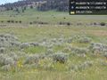
No luck. Behind a locked gate. Antelope in the field though! @44.6861,-111.4382
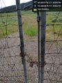
No trespassing. :-( @44.6861,-111.4382
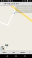
Geohash Droid. 236 m away.


