Difference between revisions of "2016-07-02 47 106"
imported>Felix Dance (An expedition message sent via Geohash Droid for Android.) |
m |
||
| (13 intermediate revisions by 3 users not shown) | |||
| Line 13: | Line 13: | ||
| lon=106 | | lon=106 | ||
| date=2016-07-02 | | date=2016-07-02 | ||
| + | | retro=1 | ||
}} | }} | ||
| Line 19: | Line 20: | ||
== Location == | == Location == | ||
| − | + | On a spur south of Ulaanbataar. | |
== Participants == | == Participants == | ||
<!-- who attended: If you link to your wiki user name in this section, your expedition will be picked up by the various statistics generated for geohashing. You may use three tildes ~ as a shortcut to automatically insert the user signature of the account you are editing with. | <!-- who attended: If you link to your wiki user name in this section, your expedition will be picked up by the various statistics generated for geohashing. You may use three tildes ~ as a shortcut to automatically insert the user signature of the account you are editing with. | ||
--> | --> | ||
| − | + | *[[User:Felix Dance|Felix Dance]] | |
| − | + | *[[User:Kathryngw|Kathryngw]] | |
| − | |||
== Expedition == | == Expedition == | ||
<!-- how it all turned out. your narrative goes here. --> | <!-- how it all turned out. your narrative goes here. --> | ||
| + | === Sunday 3 July === | ||
| + | Kathryn and I had got back from Ulgii in Western Mongolia where we spent a couple of weeks horse riding in the Altai Mountains. We'd made it to Ulaanbataar in time for the Australian election, on which we engorged ourselves for the entire beery day. | ||
| + | |||
| + | In the morning I had the epiphany of looking up the geohash locales. And boy, what a sweetie - on a ridge just 5kms south of our hostel. Off for a walk we went. Mongolia's first geohash. | ||
| + | |||
| + | The sun shone so, also owing to a dearth of taxis, we decided to walk. Within minutes, though, we spotted a bike shop, and thus procured some hired bikes to proceed in a more hastily fashion. | ||
| + | |||
| + | Through town, over the river, the sun drenching the windscreens of passing motorists. A glorious ride up into the decaying wasteland of post-boom unfinished housing construction burbs. | ||
| + | |||
| + | At the junction of the public road and the gradually deteriorating abandoned site roads I thought about what an ideal day and location had been granted to us. Perhaps my insistence of the lack of deities controlling affairs had been misplaced. | ||
| + | |||
| + | At that moment I became suspicious. I rechecked the hash droid, anxiety welling within me. Yes. This hash was for yesterday. Today's was unreachable. | ||
| − | + | Foolishly I immediately alerted Kathryn, whose deflated enthusiasm slowed her down after we decided to reach the point anyway. | |
| − | + | ||
| + | We locked up the bikes and trudged up the hill with an attitude of grim resolution. The view of Ulaanbataar swelled below us, revealing the city to be much taller and vaster than we'd suspected from within it. We took some photos from the top of a coll before sidling around to yesterday's geohash. We returned home via the river bike path, I singing Gilbert and Sullivan's 'My Eyes Are Fully Open'. | ||
| + | |||
| + | We commiserated ourselves by seeing the destruction of the world in Independence Day 2 at the cinema. | ||
== Photos == | == Photos == | ||
| Line 39: | Line 54: | ||
--> | --> | ||
<gallery perrow="5"> | <gallery perrow="5"> | ||
| + | |||
| + | Image:2016-07-02_47_106_Felix Dance_1467524294332.jpg|Geohash cock-up! Wrong day 😞 [http://www.openstreetmap.org/?lat=47.87037830&lon=106.92483230&zoom=16&layers=B000FTF @47.8704,106.9248] | ||
| + | |||
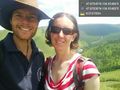
| + | Image:2016-07-03 47 106 Felix.JPG|Felix 90m from 'hash' | ||
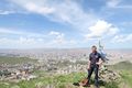
| + | Image:2016-07-03 47 106 City.JPG|Ulaanbataar from the coll | ||
| + | Image:2016-07-03 47 106 GPS.png|GPS proof of failure | ||
</gallery> | </gallery> | ||
| Line 45: | Line 66: | ||
<!-- Add any achievement ribbons you earned below, or remove this section --> | <!-- Add any achievement ribbons you earned below, or remove this section --> | ||
| − | + | [[Category:Retro meetup]] | |
| − | |||
| − | [[Category: | ||
| − | |||
| − | |||
| − | |||
| − | |||
| − | |||
| − | |||
| − | |||
| − | |||
| − | |||
| − | |||
| − | |||
| − | |||
| − | |||
[[Category:Expeditions with photos]] | [[Category:Expeditions with photos]] | ||
| − | [[Category: | + | [[Category:Retro coordinates reached]] |
| − | + | {{location|MN|1}} | |
| − | |||
| − | |||
| − | |||
| − | |||
| − | |||
| − | |||
| − | |||
| − | |||
| − | |||
| − | |||
| − | |||
| − | |||
| − | |||
| − | |||
| − | |||
| − | |||
| − | |||
| − | |||
| − | |||
| − | |||
| − | |||
| − | |||
Latest revision as of 18:51, 11 September 2021
| Sat 2 Jul 2016 in 47,106: 47.8704471, 106.9248640 geohashing.info google osm bing/os kml crox |
Location
On a spur south of Ulaanbataar.
Participants
Expedition
Sunday 3 July
Kathryn and I had got back from Ulgii in Western Mongolia where we spent a couple of weeks horse riding in the Altai Mountains. We'd made it to Ulaanbataar in time for the Australian election, on which we engorged ourselves for the entire beery day.
In the morning I had the epiphany of looking up the geohash locales. And boy, what a sweetie - on a ridge just 5kms south of our hostel. Off for a walk we went. Mongolia's first geohash.
The sun shone so, also owing to a dearth of taxis, we decided to walk. Within minutes, though, we spotted a bike shop, and thus procured some hired bikes to proceed in a more hastily fashion.
Through town, over the river, the sun drenching the windscreens of passing motorists. A glorious ride up into the decaying wasteland of post-boom unfinished housing construction burbs.
At the junction of the public road and the gradually deteriorating abandoned site roads I thought about what an ideal day and location had been granted to us. Perhaps my insistence of the lack of deities controlling affairs had been misplaced.
At that moment I became suspicious. I rechecked the hash droid, anxiety welling within me. Yes. This hash was for yesterday. Today's was unreachable.
Foolishly I immediately alerted Kathryn, whose deflated enthusiasm slowed her down after we decided to reach the point anyway.
We locked up the bikes and trudged up the hill with an attitude of grim resolution. The view of Ulaanbataar swelled below us, revealing the city to be much taller and vaster than we'd suspected from within it. We took some photos from the top of a coll before sidling around to yesterday's geohash. We returned home via the river bike path, I singing Gilbert and Sullivan's 'My Eyes Are Fully Open'.
We commiserated ourselves by seeing the destruction of the world in Independence Day 2 at the cinema.
Photos
Geohash cock-up! Wrong day 😞 @47.8704,106.9248
Felix 90m from 'hash'
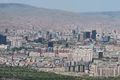
Ulaanbataar from the coll
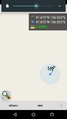
GPS proof of failure


