Difference between revisions of "2016-07-10 52 4"
imported>FelixTheCat (Created page with "{{subst:Expedition |lat = 52 |lon = 4 |date = 2016-07-10 }}") |
imported>FippeBot m (Location) |
||
| (2 intermediate revisions by one other user not shown) | |||
| Line 1: | Line 1: | ||
| − | |||
| − | |||
| − | |||
| − | |||
| − | |||
| − | |||
| − | |||
| − | |||
| − | |||
| − | |||
{{meetup graticule | {{meetup graticule | ||
| lat=52 | | lat=52 | ||
| Line 14: | Line 4: | ||
| date=2016-07-10 | | date=2016-07-10 | ||
}} | }} | ||
| − | |||
| − | |||
__NOTOC__ | __NOTOC__ | ||
| − | |||
== Location == | == Location == | ||
| − | + | A field in Heemskerk, Noord-Holland province. | |
== Participants == | == Participants == | ||
| − | + | [[User:FelixTheCat|FelixTheCat]] ([[User talk:FelixTheCat|talk]]) | |
| − | |||
| − | |||
| − | |||
| − | |||
== Expedition == | == Expedition == | ||
| − | + | As part of my quest to visit all [https://en.wikipedia.org/wiki/List_of_World_Heritage_Sites_in_the_Netherlands UNESCO World Heritage Sites in the Netherlands], I was planning to visit a few forts belonging to the [https://en.wikipedia.org/wiki/Stelling_van_Amsterdam Defence Line of Amsterdam], which usually only open on Sundays. It was therefore quite a coincidence that this Sunday's hash was just 1 km away from Fort Veldhuis. It appeared to be located in a city park of some sort, so it should have been easy to reach. | |
| − | + | Alas, as I approached the hash it turned out that one large section of what looked like a park was actually a fenced-off meadow. Although no livestock was on duty, it still looked like the only way to get to the hash would be to either jump across a stream or crawl over/under a fence. Oh well, at least I scored another point towards the Posted Achievement.... | |
| − | |||
== Photos == | == Photos == | ||
| − | |||
| − | |||
| − | |||
<gallery perrow="5"> | <gallery perrow="5"> | ||
| + | Image:2016-07-10 52 4 FelixTheCat 1.JPG | The hash is somewhere in the bushy area across the water. | ||
| + | Image:2016-07-10 52 4 FelixTheCat 2.JPG | The far end of this park is apparently a piece of "Struinnatuur". The verb ''struinen'' means something like "wander" or "browse", so this is a well-defined area where one is free to roam about. Naturally, the freedom to roam is tightly regulated here.... | ||
| + | Image:2016-07-10 52 4 FelixTheCat 3.JPG | The grass on the other side of the stream is largely fenced off however. Note that the part on the right is still ''struinnatuur'', so you're free to wander around over there. | ||
| + | Image:2016-07-10 52 4 FelixTheCat 4.JPG | Alas, no other means of getting to the other side. | ||
| + | Image:2016-07-10 52 4 FelixTheCat 5.png | Failed! | ||
</gallery> | </gallery> | ||
== Achievements == | == Achievements == | ||
{{#vardefine:ribbonwidth|800px}} | {{#vardefine:ribbonwidth|800px}} | ||
| − | + | {{No trespassing | |
| − | + | | latitude = 52 | |
| − | + | | longitude = 4 | |
| − | + | | date = 2016-07-10 | |
| − | + | | name = [[User:FelixTheCat|FelixTheCat]] ([[User talk:FelixTheCat|talk]]) | |
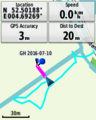
| − | + | | distance = 20m | |
| − | + | }} | |
| − | |||
| − | |||
| − | |||
| − | |||
| − | |||
| − | |||
| − | |||
| − | |||
| − | |||
[[Category:Expeditions]] | [[Category:Expeditions]] | ||
| − | |||
[[Category:Expeditions with photos]] | [[Category:Expeditions with photos]] | ||
| − | |||
| − | |||
| − | |||
| − | |||
| − | |||
| − | |||
| − | |||
| − | |||
| − | |||
[[Category:Coordinates not reached]] | [[Category:Coordinates not reached]] | ||
| − | |||
| − | |||
| − | |||
| − | |||
| − | |||
[[Category:Not reached - No public access]] | [[Category:Not reached - No public access]] | ||
| − | + | {{location|NL|NH}} | |
| − | |||
| − | |||
| − | |||
| − | |||
| − | |||
| − | |||
| − | |||
Latest revision as of 00:59, 16 August 2019
| Sun 10 Jul 2016 in 52,4: 52.5020188, 4.6925195 geohashing.info google osm bing/os kml crox |
Location
A field in Heemskerk, Noord-Holland province.
Participants
Expedition
As part of my quest to visit all UNESCO World Heritage Sites in the Netherlands, I was planning to visit a few forts belonging to the Defence Line of Amsterdam, which usually only open on Sundays. It was therefore quite a coincidence that this Sunday's hash was just 1 km away from Fort Veldhuis. It appeared to be located in a city park of some sort, so it should have been easy to reach.
Alas, as I approached the hash it turned out that one large section of what looked like a park was actually a fenced-off meadow. Although no livestock was on duty, it still looked like the only way to get to the hash would be to either jump across a stream or crawl over/under a fence. Oh well, at least I scored another point towards the Posted Achievement....
Photos
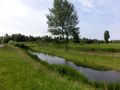
The hash is somewhere in the bushy area across the water.
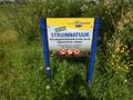
The far end of this park is apparently a piece of "Struinnatuur". The verb struinen means something like "wander" or "browse", so this is a well-defined area where one is free to roam about. Naturally, the freedom to roam is tightly regulated here....
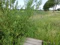
The grass on the other side of the stream is largely fenced off however. Note that the part on the right is still struinnatuur, so you're free to wander around over there.
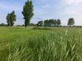
Alas, no other means of getting to the other side.
Failed!


Achievements
FelixTheCat (talk) earned the No trespassing consolation prize
|