Difference between revisions of "2016-08-08 37 -107"
imported>Mcbaneg m (Mcbaneg moved page 20416-08-08 37 -107 to 2016-08-08 37 -107: superfluous 4 accidentally typed into date part of page title) |
imported>FippeBot m (Location) |
||
| Line 63: | Line 63: | ||
[[Category:Expeditions with photos]] | [[Category:Expeditions with photos]] | ||
[[Category:Coordinates not reached]] | [[Category:Coordinates not reached]] | ||
| + | {{location|US|CO|SM}} | ||
Revision as of 02:06, 7 August 2019
| Mon 8 Aug 2016 in 37,-107: 37.7770541, -107.9715638 geohashing.info google osm bing/os kml crox |
Location
Steep bank on north side of CO145, Rico, CO
Participants
Expedition
In Colorado for a week, with afternoons open for hiking and geohashing. This was the only day we tried for a hashpoint (the Tuesday might have been more accessible but we made a different hike instead.) This one looked like no problem, with the hashpoint only about 400 m from the road and no obvious obstacles on the satmap. Upon arrival, though, it turned out that that 400 m was on roughly a 45 degree slope. Three of us tried it, climbing a good way above the road, but after about 10 minutes that got us only marginally closer to the hashpoint we abandoned the attempt and took the Cliffs of Despair consolation prize. Susanne had the good sense to stay by the car.
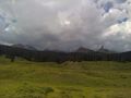
View to north, toward Lizard Head Peak, from our closest approach.
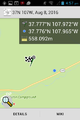
Closest we got.
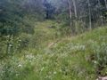
Shot upslope toward the hashpoint. The photo doesn't really make the grade clear.


Achievements
Mcbaneg, Katja, and Rebekah earned the Cliffs of Despair consolation prize
|