Difference between revisions of "2016-09-14 49 8"
imported>DODO (→Plans) |
imported>FippeBot m (Location) |
||
| (7 intermediate revisions by one other user not shown) | |||
| Line 32: | Line 32: | ||
== Expedition == | == Expedition == | ||
| − | + | I reached the station Mainz Römisches Theater at a quarter to six. That is quite late, considering that I still have 88 kilometers to go by train. I rode to the rhine river and followed it for a while, then the way left the river and followed the railway to Laubenheim and Bodenheim. After Bodenheim I entered some vineyards and the relief got more pronounced. At half past six I reached a road and the hash was close. I parked my bike, crossed the road and was stopped by a fence. On the other side was a horse meadow. Maybe I could have entered it, it seemed that the horses were on a adjacent meadow, distinct by another fence, but it was so late already that I didn't try. So I'm still waiting for my first multi hash. I took some pictures and continued my way to Nackenheim from where I took the train home. | |
== Tracklog == | == Tracklog == | ||
| − | + | [https://www.komoot.de/tour/12370496 17 KM by bike]. I didn't track the 88 KM by train from Nackenheim home. | |
== Photos == | == Photos == | ||
| − | < | + | <gallery perrow="6"> |
| − | Image: | + | Image: 2016-09-14 49 7-07.jpg|the fence. Somewhere on the other side |
| − | -- | + | Image: 2016-09-14 49 7-08.jpg|view to the east ... |
| − | + | Image: 2016-09-14 49 7-09.jpg|and the west | |
| + | Image: 2016-09-14 49 7-10.jpg|unhappy hasher | ||
| + | Image: 2016-09-14 49 7-11.jpg|bike | ||
| + | Image: 2016-09-14 49 8-13.png|38 m, the closest I got | ||
</gallery> | </gallery> | ||
| Line 48: | Line 51: | ||
<!-- Add any achievement ribbons you earned below, or remove this section --> | <!-- Add any achievement ribbons you earned below, or remove this section --> | ||
| − | + | {{No trespassing | |
| − | + | | latitude = 49 | |
| − | + | | longitude = 8 | |
| + | | date = 2016-09-14 | ||
| + | | name = DODO | ||
| + | | distance = 37m | ||
| − | + | }} | |
| − | |||
| − | |||
| − | |||
| − | |||
| − | |||
| − | |||
| − | |||
| − | |||
[[Category:Expeditions]] | [[Category:Expeditions]] | ||
| − | |||
| − | |||
| − | |||
| − | |||
| − | |||
| − | |||
| − | |||
| − | |||
| − | |||
| − | |||
| − | |||
[[Category:Coordinates not reached]] | [[Category:Coordinates not reached]] | ||
| − | |||
| − | |||
| − | |||
| − | |||
| − | |||
[[Category:Not reached - No public access]] | [[Category:Not reached - No public access]] | ||
| − | + | {{location|DE|RP|MZ}} | |
| − | |||
| − | |||
| − | |||
| − | |||
| − | |||
| − | |||
| − | |||
Latest revision as of 01:27, 16 August 2019
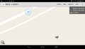
| Wed 14 Sep 2016 in 49,8: 49.9039503, 8.3133083 geohashing.info google osm bing/os kml crox |
Location
A horse-meadow between Lörzweiler and Nackenheim.
Participants
Plans
After I've crossed the Hunsrück-mountains for the Kaiserslautern-hash, I had to change trains in Mainz. But the station ist only 11 kilometers from this point. Of course I had to try to get there.
Expedition
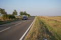
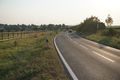
I reached the station Mainz Römisches Theater at a quarter to six. That is quite late, considering that I still have 88 kilometers to go by train. I rode to the rhine river and followed it for a while, then the way left the river and followed the railway to Laubenheim and Bodenheim. After Bodenheim I entered some vineyards and the relief got more pronounced. At half past six I reached a road and the hash was close. I parked my bike, crossed the road and was stopped by a fence. On the other side was a horse meadow. Maybe I could have entered it, it seemed that the horses were on a adjacent meadow, distinct by another fence, but it was so late already that I didn't try. So I'm still waiting for my first multi hash. I took some pictures and continued my way to Nackenheim from where I took the train home.
Tracklog
17 KM by bike. I didn't track the 88 KM by train from Nackenheim home.
Photos
the fence. Somewhere on the other side
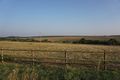
view to the east ...
and the west

unhappy hasher
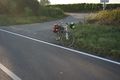
bike
38 m, the closest I got


Achievements
DODO earned the No trespassing consolation prize
|