Difference between revisions of "2016-10-30 51 4"
imported>FelixTheCat (Created page with "{{subst:Expedition |lat = 51 |lon = 4 |date = 2016-10-30 }}") |
imported>FippeBot m (Location) |
||
| (3 intermediate revisions by 2 users not shown) | |||
| Line 1: | Line 1: | ||
| − | |||
| − | |||
| − | |||
| − | |||
| − | |||
| − | |||
| − | |||
| − | |||
| − | |||
| − | |||
{{meetup graticule | {{meetup graticule | ||
| lat=51 | | lat=51 | ||
| Line 14: | Line 4: | ||
| date=2016-10-30 | | date=2016-10-30 | ||
}} | }} | ||
| − | |||
| − | |||
__NOTOC__ | __NOTOC__ | ||
| − | |||
== Location == | == Location == | ||
| − | + | Ackerdijkse plassen nature reserve in Oude Leede. | |
== Participants == | == Participants == | ||
| − | + | *[[User:FelixTheCat|FelixTheCat]] ([[User talk:FelixTheCat|talk]]) | |
| − | + | *[[User:Palmpje|Palmpje]] | |
| − | |||
| − | |||
| − | |||
== Expedition == | == Expedition == | ||
| − | + | * FelixTheCat | |
| + | After my failed expedition [[2016-10-30 51 5 |earlier today]] I decided to also go for this one, a bit nearer to home. I got on my bike around 17:30, hoping to get there before dark. The sun had pretty much set by the time I reached the nature reserve, so I had to hurry up as it officially closes at sunset. Alas, it was no use anyway: most of the reserve is a no-go area to protect the birds and other animals living there, so again I could not reach the hash. With the sun gone, there was not much left to see so I got back on my bike and went home again. | ||
| + | *Palmpje | ||
| + | At first this one looked promising as there appeared to be a path to almost the cache. But alas, this is a protected nature area so I knew beforehand that I would not be able to reach the hash. But there was a geocache nearby that I wanted to log so I went out anyway. First I walked along the Berkelsche Zweth to find that cache. Funny with the nature reserve at the right and the Rotterdam skyline on the left. And in between Rotterdam Airport with planes taking off making quite some noise. | ||
| − | + | After finding the cache GCGQE2 I moved the hash-carriage a bit and walked to the bird-lookout that overviews the hashpoint. About 2 hours before Felix was there I logged the cache located in the lookout and walked to another lookout point a tower this time (why did I not take a picture?). After logging the cache in that lookout I drove to Delft to log two more puzzle caches and in the dark I returned to my home graticule 52, 4 | |
| − | |||
== Photos == | == Photos == | ||
| − | < | + | * FelixTheCat |
| − | Image: | + | <gallery perrow="5"> |
| − | --> | + | Image:2016-10-30 51 4 FelixTheCat 1.JPG | The Sun setting over Delft. Happens an hour earlier than last week due to the DST switch this weekend. |
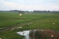
| + | Image:2016-10-30 51 4 FelixTheCat 2.JPG | A view of the nature reserve, looking towards Rotterdam. | ||
| + | Image:2016-10-30 51 4 FelixTheCat 3.JPG | No, that's not the sun setting. These are the bright lights used in greenhouses to stimulate plant growth outside daylight hours. | ||
| + | Image:2016-10-30 51 4 FelixTheCat 4.png | 200 metres to go. Failed again! | ||
| + | Image:2016-10-30 51 4 FelixTheCat 5.JPG | Lloyd looking out over the fields. | ||
| + | </gallery> | ||
| + | * Palmpje | ||
<gallery perrow="5"> | <gallery perrow="5"> | ||
| + | Image:2016_10_30_52_4-Palmpje 001.JPG | Trying to get a picture of the distance to the hash -> Failure! | ||
| + | Image:2016_10_30_52_4-Palmpje 002.JPG | The hashpoint is in front of that line of trees | ||
| + | Image:2016_10_30_52_4-Palmpje 003.JPG | View from the tower to the north of the hashpoint, the point is to the left of that ugly bright spot in the middle. | ||
| + | Image:2016_10_30_52_4-Palmpje 004.JPG | No access | ||
| + | Image:2016_10_30_52_4-Palmpje 005.JPG | Although they were allowed entry. | ||
</gallery> | </gallery> | ||
| + | |||
== Achievements == | == Achievements == | ||
{{#vardefine:ribbonwidth|800px}} | {{#vardefine:ribbonwidth|800px}} | ||
| − | + | {{No trespassing | |
| + | | latitude = 51 | ||
| + | | longitude = 4 | ||
| + | | date = 2016-10-30 | ||
| + | | name = [[User:FelixTheCat|FelixTheCat]] ([[User talk:FelixTheCat|talk]]) and [[User:Palmpje|Palmpje]] | ||
| + | | distance = 198m | ||
| + | }} | ||
| − | |||
| − | |||
| − | |||
| − | |||
| − | |||
| − | |||
| − | |||
| − | |||
| − | |||
| − | |||
| − | |||
| − | |||
| − | |||
| − | |||
[[Category:Expeditions]] | [[Category:Expeditions]] | ||
| − | |||
[[Category:Expeditions with photos]] | [[Category:Expeditions with photos]] | ||
| − | |||
| − | |||
| − | |||
| − | |||
| − | |||
| − | |||
| − | |||
| − | |||
| − | |||
[[Category:Coordinates not reached]] | [[Category:Coordinates not reached]] | ||
| − | |||
| − | |||
| − | |||
| − | |||
| − | |||
[[Category:Not reached - No public access]] | [[Category:Not reached - No public access]] | ||
| − | + | {{location|NL|ZH}} | |
| − | |||
| − | |||
| − | |||
| − | |||
| − | |||
| − | |||
| − | |||
Latest revision as of 01:41, 16 August 2019
| Sun 30 Oct 2016 in 51,4: 51.9777143, 4.4175204 geohashing.info google osm bing/os kml crox |
Location
Ackerdijkse plassen nature reserve in Oude Leede.
Participants
Expedition
- FelixTheCat
After my failed expedition earlier today I decided to also go for this one, a bit nearer to home. I got on my bike around 17:30, hoping to get there before dark. The sun had pretty much set by the time I reached the nature reserve, so I had to hurry up as it officially closes at sunset. Alas, it was no use anyway: most of the reserve is a no-go area to protect the birds and other animals living there, so again I could not reach the hash. With the sun gone, there was not much left to see so I got back on my bike and went home again.
- Palmpje
At first this one looked promising as there appeared to be a path to almost the cache. But alas, this is a protected nature area so I knew beforehand that I would not be able to reach the hash. But there was a geocache nearby that I wanted to log so I went out anyway. First I walked along the Berkelsche Zweth to find that cache. Funny with the nature reserve at the right and the Rotterdam skyline on the left. And in between Rotterdam Airport with planes taking off making quite some noise.
After finding the cache GCGQE2 I moved the hash-carriage a bit and walked to the bird-lookout that overviews the hashpoint. About 2 hours before Felix was there I logged the cache located in the lookout and walked to another lookout point a tower this time (why did I not take a picture?). After logging the cache in that lookout I drove to Delft to log two more puzzle caches and in the dark I returned to my home graticule 52, 4
Photos
- FelixTheCat
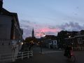
The Sun setting over Delft. Happens an hour earlier than last week due to the DST switch this weekend.
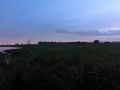
A view of the nature reserve, looking towards Rotterdam.
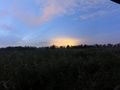
No, that's not the sun setting. These are the bright lights used in greenhouses to stimulate plant growth outside daylight hours.
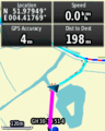
200 metres to go. Failed again!
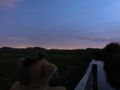
Lloyd looking out over the fields.


- Palmpje
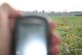
Trying to get a picture of the distance to the hash -> Failure!
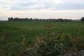
The hashpoint is in front of that line of trees
View from the tower to the north of the hashpoint, the point is to the left of that ugly bright spot in the middle.
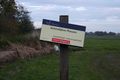
No access
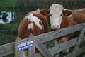
Although they were allowed entry.


Achievements
FelixTheCat (talk) and Palmpje earned the No trespassing consolation prize
|