Difference between revisions of "2017-01-28 -37 145"
From Geohashing
imported>Kozz ([live] Hooray! One that's really close. I'll be heading out there shortly.) |
m |
||
| (14 intermediate revisions by 4 users not shown) | |||
| Line 19: | Line 19: | ||
== Location == | == Location == | ||
| − | + | 39 Croydon Road, Mont Albert | |
== Participants == | == Participants == | ||
| − | + | [[User:Kozz|Kozz]] ([[User talk:Kozz|talk]]) | |
| − | + | == Plans == | |
| + | This is like 5km from my house and close to the train station I used to use (Chatham). | ||
| − | + | 5km is too close to ride to so I'll make it into a longer ride. | |
| − | |||
== Expedition == | == Expedition == | ||
| − | + | I pretty much went the same route as the hash last weekend, along the Gardiner's Creek trail to the Yarra trail then through Yarra Boulevard and back along bike trails through to Mont Albert Rd. From there it was a quick detour to Coventry Road although it was hard to get within 10 metres of the hash as it was right inside the property and they're currently replacing the bluestone guttering. | |
| − | |||
| − | |||
== Tracklog == | == Tracklog == | ||
| − | |||
== Photos == | == Photos == | ||
| Line 41: | Line 38: | ||
--> | --> | ||
<gallery perrow="5"> | <gallery perrow="5"> | ||
| − | |||
| − | + | Image:2017-01-28_-37_145_kozz_1485547750828.jpg|Close as I got | |
| − | + | ||
| − | + | Image:2017-01-28_-37_145_kozz_1485547773323.jpg|Nearby cricket ground | |
| + | |||
| + | Image:2017-01-28_-37_145_kozz_1485547795085.jpg|Riding the trails | ||
| − | + | Image:2017-01-28_-37_145_kozz_1485547825825.jpg|Early start | |
| − | |||
| − | |||
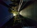
| − | + | Image:2017-01-28_-37_145_kozz_1485547862998.jpg|It dark | |
| − | + | Image:2017-01-28_-37_145_kozz_1485548370096.jpg|The hash house | |
| − | < | + | </gallery> |
| − | |||
| − | |||
| − | + | == Achievements == | |
| + | {{bicycle geohash | ||
| + | | latitude = -37 | ||
| + | | longitude = 145 | ||
| + | | date = 2017-01-28 | ||
| + | | name = [[User:Kozz|Kozz]] ([[User talk:Kozz|talk]]) | ||
| + | | distance = 46.84km | ||
| + | | bothways = true (optional) | ||
| + | | image = 2017-01-28_-37_145_kozz_1485547862998.jpg | ||
| + | }} | ||
| − | + | {{#vardefine:ribbonwidth|800px}} | |
[[Category:Expeditions]] | [[Category:Expeditions]] | ||
| − | |||
[[Category:Expeditions with photos]] | [[Category:Expeditions with photos]] | ||
| − | [[Category:Expeditions with videos]] | + | [[Category:Expeditions with videos]] |
| − | |||
| − | |||
| − | |||
| − | |||
| − | |||
| − | |||
| − | |||
| − | |||
[[Category:Coordinates not reached]] | [[Category:Coordinates not reached]] | ||
| − | |||
| − | |||
| − | |||
| − | |||
| − | |||
[[Category:Not reached - No public access]] | [[Category:Not reached - No public access]] | ||
| − | + | {{location|AU|VIC|BO}} | |
| − | |||
| − | |||
| − | |||
| − | |||
| − | |||
| − | |||
| − | |||
Latest revision as of 10:24, 12 September 2021
| Sat 28 Jan 2017 in -37,145: -37.8227702, 145.0907784 geohashing.info google osm bing/os kml crox |
Location
39 Croydon Road, Mont Albert
Participants
Plans
This is like 5km from my house and close to the train station I used to use (Chatham).
5km is too close to ride to so I'll make it into a longer ride.
Expedition
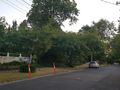
I pretty much went the same route as the hash last weekend, along the Gardiner's Creek trail to the Yarra trail then through Yarra Boulevard and back along bike trails through to Mont Albert Rd. From there it was a quick detour to Coventry Road although it was hard to get within 10 metres of the hash as it was right inside the property and they're currently replacing the bluestone guttering.
Tracklog
Photos
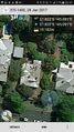
Close as I got
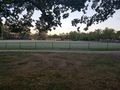
Nearby cricket ground
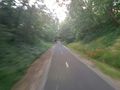
Riding the trails
Early start
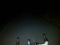
It dark
The hash house


Achievements
Kozz (talk) earned the Bicycle geohash achievement
|